
Page 14 - nt_tsw_en
P. 14
2. Hung Shui Kiu/Ha Tsuen
New Development Area
Geographical Context
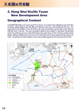
The HSK/HT NDA (Figure 27) covers about 710 ha of land. It is located in the northwestern part of the New
Territories, midway between the Tuen Mun and TSW New Towns and covering HSK and HT areas. It is
surrounded by the ridgeline of Yuen Tau Shan in the west and northwest, Lau Fau Shan in the north and
TSW New Town in the east. The area is generally bounded by the existing Tin Ying Road, Ping Ha Road
and Kiu Hung Road to the east, Castle Peak Road to the south, knolls of Yuen Tau Shan and Kong Sham
Western Highway (KSWH) to the west and Lau Fau Shan Road and hill slope along Deep Bay Road to the
north . According to the 2021 Population Census, the existing population of the area was about 44 500.
Figure 27: Location of Hung Shui Kiu/Ha Tsuen New Development Area
13