
Page 23 - nt_tsw_en
P. 23
Transport
The railway system is planned as the backbone of the passenger transport system in the NDA. It
comprises Tuen Ma Line and Light Rail supplemented by other public transport services. To support
the development of the HSK/HT NDA, a number of improvements to the existing road network are
necessary. With the implementation of the proposed improvement works, no adverse traffic impact is
envisaged.
External Connectivity
The HSK/HT NDA will be connected with the urban areas through mass transit with the proposed
HSK Station and the existing TSW Station of the Tuen Ma Line Four PTIs will also be provided in the
NDA. For the road network, a new primary distributor is planned underneath Kong Sham Western
Highway which would divert traffic from the Logistics, Enterprise and Technology Quarter, avoiding
heavy vehicles to use the roads within the residential neighbourhood. The Government will continue
to monitor the changing needs of the NWNT traffic road network and carry out a feasibility study on
Route 11 connecting North Lantau and Yuen Long with a view to improving the accessibility of the
NWNT.
Internal Connectivity
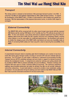
A comprehensive transport network comprising eight district distributors and a number of new local
roads with various green transport modes including an exclusive GTC will serve internal vehicular
movement. The GTC (Figure 37) will include a rail-based or road-based Environmentally Friendly
Transport Services (EFTS), pedestrian walkways and cycle tracks to support the internal movement
between the development clusters. A comprehensive pedestrian walkway and cycling network will
be provided in HSK/HT NDA to promote walkability and cycle friendliness. Pedestrian walkways will
integrate with open space to create a pleasant walking environment. The continuous pedestrian
walkways along riverside promenades and under the elevated Tuen Ma Line will provide northsouth
vehicle-free connections. A cycle track network is planned to provide a more comfortable cycling
environment. It is also planned to link up the existing cycle track network in the HSK/HT NDA and TSW
New Town to provide convenient connections for the local communities.
Figure 37: Artist Impression of Green Transit Corridor
22