6.1 INTRODUCTION
6.1.1 This chapter of the Report describes in broad terms, the findings of the survey of the landscape of Hong Kong as well as the resultant Landscape Character Map. In particular, it presents the following:
Key Components of the Hong Kong Landscape;
Historic Development of the Hong Kong Landscape;
Overview by Area of the Landscape Character of the Hong Kong;
Discussion of Different Landscape Types found Across Hong Kong;
Distinctive Landscapes in Hong Kong; and
Analysis of Field Survey Data.
6.1.2 The findings represent the status of the Hong Kong Landscape at the date of completion of the survey process in 2003 (with some minor checking and amendment carried out after this).
6.2 KEY COMPONENTS OF THE HONG KONG LANDSCAPE
Introduction
6.2.1 Hong Kong lies on the south-eastern coast of the East Asia landmass between latitudes 22 degrees 09' and 22 degrees 37'N to the east of the Pearl River estuary. The region consists of an extensive area of the mainland landmass together with numerous islands, the largest of which are Lantau Island (142 km2), Hong Kong Island (78 km2) and Lamma Island (13.5 km2). The total land area is 1076 km2, of which over 40 km2 is the result of land reclamation.
6.2.2 The topography is extremely rugged and there is little natural flat land. A series of ridges make up the backbone of the Territory, mostly running from northeast to southwest. The highest point is at Tai Mo Shan (957 m) in the central New Territories, followed by Lantau Peak (934 m) and Sunset Peak (869 m) on Lantau Island.
6.2.3 In the last 150 years, Hong Kong's population has grown from only around 3000 people to over six million. Because of the rugged terrain, 95% of the population live and work in less than 20% of land, and the remaining 80% of land is relatively undeveloped.
The Influence of Climate on the Landscape
6.2.4 Hong Kong has a sub-tropical, monsoon climate, dominated by seasonal changes of wind direction and the resulting major contrast in weather between winter and summer. In winter (from November to February), easterly winds bring cool, dry air to Hong Kong, whilst in summer (May to September) moist air from over the oceans moves across the HKSAR.
6.2.5 The mean annual temperature is 22.8°C (1961-90) ranging between a mean of 15.8°C in January and 28.8°C in July. Temperature is obviously a key factor in determining the types of vegetation which characterise the Hong Kong landscape, but also has an effect on the chemical weathering or rock.
6.2.6 Mean annual rainfall in Hong Kong is 2214 mm, with 77% of the total annual rainfall falling between May and September, as opposed to only 6% in the four winter months. Approximately 18% of the annual rainfall – more than twice the monthly average – falls in August. Summer is also the main typhoon season and typhoons passing within several hundred kilometers of Hong Kong contribute about 25% of the annual rainfall in the latter part of the summer. Extreme rainfall events are of major significance for the landscape by promoting erosion of hillsides, flooding and landslides. The great majority of landslides occur during high-intensity rainfalls. Rainfall extremes are sometimes associated with typhoons, which also bring very strong winds. Another hazard associated with typhoons are storm surges which tend to accentuate flooding events in lowland valleys and consequent alluvial deposition, resulting in Hong Kong's rich valley landscapes in the New Territories.
6.2.7 The prevailing wind in Hong Kong is from the east over the summer months, except for July when there is an abrupt shift in wind direction from the south-west. The prevailing wind is from the north-east over winter months. The result in landscape terms includes the weather beaten landscapes of the islands off the NENT such as Tap Mun or Grass Island, which comprise low grassland with little other significant vegetation.
The Influence of Microclimate on the Landscape
6.2.8 Hong Kong’s climate also shows major variations across the SAR itself. Temperature declines regularly with increasing altitude (approximately 0.5°C per 100 m), but the variation in mean annual rainfall is more complex. Generally speaking the uplands of Hong Kong receive most rainfall, with the least occurring in the low-lying north-west New Territories.
6.2.9 On a smaller scale, climate varies with slope angle and orientation (or aspect). Because Hong Kong is north of the equator, a north-facing slope generally receives less solar radiation than flat land or a south-facing slope. This north-south difference increases rapidly with increasing slope angle and is at a maximum in the November-January dry season. The major impact on vegetation from this differential is probably through hill fire, with fire frequency and intensity both likely to be greater on the warmer, drier south-facing slopes. This results in generally greater coverage of woodland and tall shrubland on north-facing slopes in Hong Kong.
6.2.10 Prevailing winds also account for a stark difference in vegetation development between east and west facing slopes in much of the New Territories. Prevailing easterly winds throughout most of the year will increase evaporation and transpiration rates on east-facing slopes, marking them drier than west-facing slopes, increasing the risk of fire on these slopes.
The Influence of Geology on the Hong Kong Landscape
6.2.11 Hong Kong has a rugged topography with a highly indented complex coastline characterised by numerous bays, headlands, peninsulas and outlying islands. Most of Hong Kong's topography is steep and elevated (consisting of volcanic and granitic uplands) falling dramatically to rocky coasts. Around 47% of the Hong Kong landscape lies above 100 mPD with around 12% above 300 mPD. Thirty-two peaks are higher than 500 mPD; thirteen lie above 600 mPD; seven lie above 700 mPD and three lie above 800 mPD. The highest peaks are Tai Mo Shan (957 mPD), Lantau Peak (933 mPD) and Sunset Peak (869 mPD).
6.2.12 The uplands of the southern, central and eastern New Territories contrast with the low-lying alluvial plains of the north-west New Territories. Northeast to east/north-east-trending faults dominate the landscape and dictate the major pattern of ridges and valleys, created by differential weathering along fault lines. North-west trending faults form a subordinate grain, which dominates in the east and south-east. In addition to controlling the orientation of the main valleys, ridges and uplands, this pattern of faults also manifests itself in the shapes of estuaries, channels, bays and headlands around the coast.
6.2.13 Volcanic rocks, which are exposed over about 50% of the land area of Hong Kong, generally form the uplands in western Lantau Island, southern Hong Kong Island, and the central and eastern New Territories. The rocks consist mostly of tuffs, formed by the consolidation of volcanic ash and larger fragments ejected from ancient volcanoes. Volcanic rocks form steep, rugged and angular peaks, such as those of Tai Mo Shan, Sunset Peak, Lantau Peak, the ridge from Kowloon Peak to Tate’s Cairn, Ma On Shan, High Junk Peak, and Sharp Peak. Volcanic tuffs also form steep, cliffed coastlines, like those along the eastern shores of the New Territories.
6.2.14 By contrast, around 35% of Hong Kong lies on granitic rocks, such as those which cover northern Hong Kong Island, eastern Lantau, Kowloon, Sha Tin, the western New Territories, the Lion Rock ridge, and southern Lamma Island. These granites are variable, though the most common form is pink or grey with a medium-to-coarse grain. Other varieties have scattered large crystal in a medium-to fine-grained groundmass. Granites weather differently to volcanic tuffs and form lower more rounded peaks which support little vegetation and which are prone to weathering and erosion. The process of weathering produces 'tors', isolated blocky rocks, boulder fields and severely eroded hillsides known as 'badlands'.
6.2.15 Sedimentary rocks are exposed over about 15% of Hong Kong, mostly in the northern and north-east New Territories. They include sandstones, mudstones, conglomerates, siltstones and shales and are responsible for several distinctive, often red, landforms, such as the low-lying island of Ping Chau and the distinctive Bluff Head Formation of sedimentary rocks on the northern shore of Tolo Channel.
6.2.16 Over the lower lying areas of Hong Kong are marine and beach deposits in coastal areas and alluvium in lower parts of the larger river basins. Alluvial deposition has undoubtedly been accelerated over the course of recent history by the effects of deforestation on uplands and the resulting increase in erosion. Colluvial deposits (debris from landslides and other mass movements), often several metres thick, cover large areas inland, including hill footslopes.
The Influence of Soils on the Landscape
6.2.17 Most hill soils in Lantau Island, Hong Kong Island, Kowloon, the SENT, western and central NT and NENT are formed from the weathering of either granite or volcanic rocks. The rate of weathering is regulated by the physical properties of the rock, which determine penetration by ground water. In Hong Kong’s hot and wet climate, weathering is very intense and the breakdown of minerals so complete, that dissimilar rocks can produce soils which end up being fairly similar.
6.2.18 Hill soils in Hong Kong are therefore generally either Krasnosems (Red Loams) in areas of volcanic rock and Red-Yellow Podsols in areas of granitic rock.
6.2.19 Krasnosems are found largely on areas of volcanic rock where wet and warm conditions causes weathering of the parent material. They consist of a thin humus deficient upper layer on a very deep friable clay layer. Red or purplish in colour, they may be 40 feet deep with little variation.
6.2.20 Red-Yellow Podsols are well-developed acid soils lying mainly on areas of granitic parent material. These granitic soils have a somewhat larger soil particle size due to the fact that quartz does not weather to any significant degree. The soil is open textured and freely draining. However, they are relatively humus deficient and support little more than grass or scrub. Many such soils are badly eroded and support only sparse vegetation, while most volcanic areas have a continuous vegetation cover.
6.2.21 One conspicuous feature of granitic soils on many Hong Kong hillsides is the extent of weathering and erosion that has taken place, producing the barren gullied 'badlands' with rather sparse vegetation which are typical of hills in the southwest New Territories. Badlands are generally restricted to areas underlain by granite, where gullies (as in the Tai Lam area) may be as much as 15 m deep.
6.2.22 In the north and north-western NT, alluvial soils and sediments dominate the lowland valleys. Many of these areas consist of Paddy Soils which are poorly drained silt or silt/loam soils suitable for wet agriculture. The structure of these soils has been modified by the processes of ploughing and wet cultivation.
6.2.23 In coastal areas (especially the NWNT) soils consist of silty saline soils (or Solenchak) less suited to arable production.
Vegetation in the Hong Kong Landscape
Hong Kong's Vegetation History
6.2.24 It is likely that before the arrival of humans, Hong Kong was covered in a species-rich broadleaf rain forest. This forest was part of a larger east-Asian forested area stretching from the Equator to the Arctic tree line. With the arrival of humans, some 4000 years ago, vegetation in Hong Kong was gradually cleared for cultivation until today in the lowlands, apart from agriculture, all that remains of the older forests are fung shui woodland, relict or montane woodland in steep uninhabited valleys as well riparian vegetation along streams and waterways.
6.2.25 Vegetation in Hong Kong has historically been affected by four significant migration waves to the southern Guangdong coastal areas: the first, between the 3rd and 2nd century B.C.; the second wave between the 5th and 6th century A.D.; the third wave in the 13th century and the last in the 17th and 18th centuries. Each wave of migration to the region stressed existing agricultural capacity and led to significant impacts on vegetation and landscape.
6.2.26 In the uplands, cultivation and cutting of fuel for the lime and charcoal industries probably denuded even the highest hillsides until in the 19th Century, they were almost entirely grassland. British Foreign Secretary Lord Palmerston noted in 1841 that Hong Kong Island was a “barren island with hardly a house upon it.“
6.2.27 Reforestation programmes since World War Two have however had a dramatic effect in re-introducing (largely non-native) vegetation to upland areas. Much of this vegetation is really scrubland, but over time (and without the interruption of hill fire) the hillsides will naturally revert to their original woodland state.
Hong Kong's Vegetation Today
6.2.28 Hong Kong's vegetation today generally comprises genera in which most species are found within 10-15o of the equator, and only a minority of genera have their predominant distribution to the north. While Hong Kong's flora is largely tropical at the generic level, several major tropical families of plants are not found in Hong Kong (e.g., Burseraceae, Dipterocarpaceae, Myristicaceae). In addition, a number of largely non-tropical plant genera are better represented here than in the lowland tropics further south, notably Ericaceae, Machilus and Ilex.
6.2.29 The historic deforestation described above has resulted in the erosion of soils in many places and the succession of these areas by grassland which now covers much of Hong Kong’s upland area.
6.2.30 Woodland in Hong Kong is generally limited and lies in lowland areas, ravines or at the edges of villages. It consists of the following main communities (derived from the SUSDEV Habitat Map classification):
Lowland Forest;
Plantation or Plantation/Mixed Forest;
Fung Shui Forest;
Montane Forest; and
Riparian Woodland;
6.2.31 Elsewhere the pattern of vegetation is typically scrub vegetation at lower and medium altitudes on hillsides. This includes the following scrub communities:
Mixed Shrubland; and
Baeckia Shrubland.
6.2.32 Scrub gives way to 'Shrubby Grassland' and 'Grassland' at higher altitudes. 'Freshwater/Brackish Wetland' plant communities are found sporadically across Hong Kong, generally in the low-land valleys, but occasionally at higher altitudes. Elsewhere on the coasts, Hong Kong's vegetation types include 'Seagrass' and 'Mangrove'. Finally, there are the vegetation communities resulting from high levels of human intervention, which include 'Cultivation' and 'Urban Park'.
6.3 HISTORIC DEVELOPMENT OF THE HONG KONG LANDSCAPE
Introduction
6.3.1 Like almost every landscape on Earth, the Hong Kong landscape reflects the complex interaction of natural systems and the development of human civilization. These form a dynamic system as natural conditions (especially climate) changes over millennia and as human civilization changes and develops, placing different requirements and stresses on the landscape. This section of the report describes how the relationship between the natural components of the Hong Kong landscape and those who have settled it, has shaped and moulded the landscape from prehistoric times through to the present day.
The Formation of the Hong Kong Landscape - Geology of The Early Prehistoric Period
6.3.2 he landscape which is visible today is a relatively recent phenomenon and one that has developed over millennia. When Hong Kong's oldest rocks were laid down (some 400-360 million years ago) the climate was semi-arid. During this period, sedimentary rocks were deposited in larger rivers that crossed an open, un-vegetated, plain from nearby mountains. Rocks from this period are still visible in the North-east New Territories at Plover Cove and along the northern coast of Tolo Channel.
6.3.3 Between 360 and 320 million years ago, a shallow topical sea existed across Hong Kong. Coastal swamps were also formed, with deposited organic material producing carbon deposits which eventually formed into graphite. Today, these rocks occur on the Brothers Islands where they were mined until relatively recently.
6.3.4 Between 210-190 million years ago, a deeper marine environment developed, which was succeeded about 165-140 million years ago by a period of volcanic eruptions. Large volumes of volcanic ash and lavas were spread over the land surface, nearby sea inlets and shallow lakes. These volcanic tuffs now underlie almost 50% of Hong Kong, particularly in western Lantau, southern Hong Kong island, SENT and much of the central NT and NENT. Molten magma below the volcanoes cooled and solidified to form the granite rocks which are today exposed over about 35% of Hong Kong and which are particularly common in the western New Territories, Kowloon, northern Hong Kong Island.
6.3.5 Between 100-80 million years ago, a desert climate prevailed and Hong Kong's landscape was dominated by mountains and wide valleys. Rivers crossing the landscape flooded occasionally, leaving sediments of river sands and pebbly conglomerate rocks. These materials now form striking rocks exposed at locations such as Port Island and Pat Sin Leng.
6.3.6 Around 80-50 million years ago, the climate remained dry, but shallow salt lakes formed during wetter periods, drying out intermittently. Sedimentary rocks laid down in one of these lakes form the island of Ping Chau on coastal waters off the north-east of Hong Kong.
6.3.7 A warm humid climate over the last 60 million years has caused deep weathering of rocks across Hong Kong, although much of this material has since been removed by erosion. Weathering along joints and the pattern of faults across Hong Kong as well as subsequent erosion has created the rugged landscape of peaks and valleys which forms the basis of the landscape today.
6.3.8 During the last 2 million years, sea levels have risen and fallen many times, as glaciers have contracted and expanded in temperate and polar regions. The last major glaciation reached its maximum extent about 20-25,000 years ago, when world sea levels were about 130 metres below present day heights. At that time, the coast of Hong Kong lay about 120 km to the south of its present position. The numerous islands and highly indented coast of modern Hong Kong are part of this drowned landscape.
The Neolithic Landscape - the Middle to Late Neolithic Age (6500 to 4000 years ago)
Evolution of Topography and Coastline
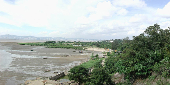
6.3.9 As the climate became warmer after last glacial period, sea levels rose, reaching present sea level around 6,000 years ago. This period marked the formation of the existing shoreline of Hong Kong SAR together with the arrival of marine-going human settlers. Though the topography of Hong Kong was largely formed by this time, weathering of rock and erosion of coasts by the sea has continued to this day. In particular, the eastern coasts of Hong Kong have been weathered by wave action into dramatic rock formations whilst the western coasts have been subject to deposition of silt carried down the Pearl River, forming the extensive mudflats landscapes of Deep Bay.
Vegetation Development
6.3.10 About 6000 to 7000 years ago, the global climate reached present day levels and since that period, Hong Kong has been situated in the transitional zone between humid tropical and warm temperate climatic types. Some experts have suggested that at the end of the last ice age, the vegetation covering the landscape of Hong Kong would probably have been a broadleaf evergreen forest, though this cannot be confirmed by evidence (Dudgeon and Corlett, 1994). Prior to human settlement around 6000 to 7000 years ago, the Hong Kong and Pearl River Delta was probably covered entirely by tropical forest (Huang and others 1983). The evidence from pollen studies of bore holes in the Shenzhen River area indicate that the broad-leaved and evergreen forest zone decreased around 7500 years ago and that grassland has increased significantly since that time (Huang and others 1983).
6.3.11 In pollen taken from soil layers dating back the Neolithic Period at Sai Kung, Poaceae and Quercus were identified. This indicates that agricultural activity began during the Neolithic Period (about 4000 – 5000 years ago). Archaeologists have also found evidence of ancient people growing rice in the Ho Chung Valley around 4000 years ago (Zhongshan University 2000). It is believed that humans living in this region cleared much of the tropical forest, causing scrubland to grow rapidly. Broadleaved forest was probably replaced by Pinus forest during this period.
Early Settlements
6.3.12 Sea level changes also influenced human settlement. Some archaeologists and linguists suggest that the Austronesians, a marine-going people, with their origins in coastal regions of South China or Taiwan (later migrating to the Pacific Islands or Southeast Asia around 6,000 to 5,500 years ago) were probably Hong Kong’s aboriginal people.
6.3.13 Settlement took place mainly in two periods: the Middle Neolithic Age and Late Neolithic Age (4,000 years to 6,500 years ago). Neolithic settlements have to date only been discovered in coastal areas and islands of the New Territories concentrated in the west or south-west of Hong Kong. These settlements were commonly in bays, on headlands, and in river mouths. Such settings provided marine food sources and a good communication and transportation network with other settlements in the Pearl River Delta region (Peacock & Nixon 1986, Ng, 1988).
6.3.14 These aboriginal peoples probably cultivated root-crops (taro, yam or sweet potato etc), traditionally cultivated in either wetlands or flood plains. However, these agricultural activities had little significant effect on the local natural landscape.
6.3.15 Pollen studies in Ho Chung in Sai Kung suggest that deforestation for agricultural production estuaries started to take place during the Late Neolithic Period around 4,000 years ago. Pinus sp. forest was replaced by Poaceae grassland and evidence suggests that rice cultivation took place in the Ho Chung river estuary at this time (Zhongshan Univ. 2000).
Population Movement and Deforestation of the Hong Kong Landscape - the Bronze Age (4000 to 3500 years ago)
Climate Change and Population Movement
6.3.16 Hong Kong and Guangdong Province entered the Bronze Age around 3,500 to 4,000 years ago. Five minor global climate fluctuations occurred between 3,500 to 4,000 years ago, as well as later, during the Ming/Qing Dynasty. These natural occurrences had a direct impact on the people and their subsistence strategies, resulting in changes to vegetation and landscape development. Reduced agricultural yields, combined with changes in sea level, forced the population to settle in inland areas, valleys and river terraces in order to expand production. As a result, the human settlements of the Bronze Age have produced patterns which are still visible in the landscape of the inland valleys today.
Bronze Age Settlement
6.3.17 Bronze Age archaeological sites have been found in river terraces in Lam Tsuen Valley, Kam Tin Valley and Shung Shui Valley as well as coastal terraces at Deep Bay. When people moved into valleys, agricultural land was formed by the dual processes of reclamation and deforestation. Studies of pollen in Pak Mong on Lantau, indicate that Pinaceae and Apocymaceae forest was destroyed during this period, with other finds of Pteris, Gramineae and Rubiaceae families from the Bronze Age (Deng and others 1997) pointing to Bronze Age cultivation of valleys.
6.3.18 The eventual outcome of deforestation was to create soil wash down from hills, peaks and consequent deposits in valleys, thus expanding and creating flood plains or mud flats along shore lines, which are still visible today in many places.
The Rise of the Salt Industry and its effect on the Hong Kong Landscape - the Early Historic Period (200 BC to 600 AD)
Han Immigration
6.3.19 After the decline of the Qin Dynasty in the 3rd century A.D., the kingdom of Nam Yue was established in the southern part of China (the present day Guangdong, Guangxi and Northern Vietnam) by the Chinese from the north. The Han people began to settle in the region and brought with them Chinese culture along with the new imperial administration and advanced rice cultivation.
The Beginnings of Salt Production
6.3.20 The Imperial Court encouraged the development of industries such as salt production, which soon became a major industry in Hong Kong. Areas between west Kowloon and Kowloon Bay were used as imperial salt production centres from the 1st century B.C onwards. Areas of Deep Bay, Tuen Mun, Mirs Bay and Lantau Island with shallow bays or inlets were all suitable places for salt production. The salt industry settlements sprang up in these areas and salt pans were reclaimed in shallow bays or inlets. The abandoned salt pans found at Tai O are a testament to the historic importance of the salt industry to the Hong Kong economy and landscape (Irving and Morton 1986).
6.3.21 Associated with these developments in the landscape was the gradual deforestation of the New Territories (Stokes, 1995), with forests gradually being replaced by scrubland or grassland during this period. It is also believed that since salt production required timber for fuel, this contributed to the deforestation. The resulting pattern of vegetation from this period remains essentially the same to this day
The Lime Industry, Industrial Settlement and Deforestation - the Middle Historic Period (700 AD to 1300 AD)
The Rise of the Lime Industry
6.3.22 Apart from salt production, Hong Kong also became home to a lime-making industry from the Tang dynasty (AD 618- 907) to the early Song dynasty. Lime kilns in Hong Kong were usually found in coastal areas, reflecting the need for coral or shells as part of the lime-making process.
6.3.23 From the 4th century A.D onwards, Tuen Mun became a major maritime custom post under the direct administration of the provincial capital in Guangzhou (Siu 1998). Between the 4th century and the 9th century, Yuen Long and Lantau Island became populated areas as a result of the lime industry. Settlements and lime kilns sprang up in many bays, inlets and valleys in these areas, creating the genesis of the settlement patterns seen today. Associated with these industries was further deforestation, in order to obtain fuel for the lime kilns. The success of this industry lead to increased settlement along Hong Kong shoreline.
6.3.24 Hong Kong's increasing prosperity resulted in a growth in the Imperial bureaucracy and in the clerical classes, which in turn in resulted in further pressure on agricultural production. At least two Buddhist temples were built during this period, one at Castle Peak, present since the 4th century (Shu 1819) and another in Ha Tsuen facing the present day new town of Tin Shui Wan (Zhang 1996). Donations of agricultural land to temples, required further agricultural expansion as compensation. Valleys and plains are believed to have been further reclaimed for cultivation of food to support the official classes which included soldiers, monks and new workers in the lime industry.
Climate Change and Further Immigration
6.3.25 Around the 11th century AD, the global temperature dropped about two degrees. This had a huge impact on the viability of lands occupied by the Mongols in northern China (Wang 2002), who moved south in search of better land. The Mongols conquered China and forced the Chinese to migrate to the south, including Guangdong and Hong Kong.
6.3.26 In subsequent centuries, population increased, as the Punti (Cantonese) peoples settled in Hong Kong. The Punti were skilled farmers and located their settlements and their agricultural lands with regard to the land's physical potential (its soils and sources of water) as well as its spiritual dimensions (fung shui). In this manner, many of Hong Kong’s inland flood plains and valleys underwent a dramatic change from a 'natural' landscape to an agricultural one. As lands were settled and reclaimed for agriculture during this period, it is almost certain that deforestation increased markedly (Stokes, 1995).
The First Fortifications
6.3.27 During the Song dynasty (AD 960 - 1279), Hong Kong was once again an important salt production centre in China creating significant imperial revenue, with official salt pans in the Tuen Mun and Yuen Long area, Kowloon and Lantau Island. However, at the same time, illegal saltpans sprang up and this resulted in a rebellion of illegal salt workers in Lantau in 1197 (Zhang 1996). This insurrection in turn resulted in imperial troops establishing a garrison on the island to protect the imperial property and to clear out the illegal salt production. These fortifications were amongst the first of many to characterise the Hong Kong landscape over the next millennium.
6.3.28 Imperial military settlements were established on Lantau and at Kowloon Bay until the late Qing Dynasty. The remains of the forts can still be seen in the landscape today, such as those at Kowloon Walled City, Tung Chung Battalion, Tung Chung Fort and Fan Lau Fort.
6.3.29 In addition to these fortifications, four principal types of settlements would have been found in Hong Kong between the 6th to 12th century:
industrial villages (salt, lime and pearl harvesting);
military settlements (Tuen Mun, Kowloon Bay, Lantau);
seasonal trader seasonal settlements and;
agricultural villages.
6.3.30 All settlements were located along the shorelines except for agricultural villages, which were usually found in plains and inland valleys. Agricultural activity increased in Hong Kong during the Song Dynasty. The five major clans of the new immigrants established their villages in the flatlands of the New Territories and one can assume that this increased settlement brought with it considerable landscape change.
The Landscape in Turmoil - the Late Historic Period (1400 to 1841)
6.3.31 Changes in political events over the next few hundred years led to relatively dramatic changes in the landscape of Hong Kong.
Piracy and Further Fortification
6.3.32 From 1494 on, Japanese pirates continuously attacked both Hong Kong and Shenzhen towns and villages, and a new coastal defence system was established along the coastline of southern China to protect the population.
6.3.33 A navy command centre was established in present day Baoan at Shenzhen City (close to Deep Bay). Its six subordinated navy garrisons included those at Tai O, Tung Lung Chau and High Island (Zhang 1996). Agricultural settlements were established close to these garrisons to support them. In the late 14th century, many families were also registered as military personnel to assist in food cultivation to support the army. At least six military farms were established on both sides of the Shenzhen River and operated until the 16th century. On the Hong Kong side of the river, these farms were found in the New Territories and Kowloon areas (Zhang 1996). It is believed that further deforestation took place in these military farm areas.
Exodus and Re-population
6.3.34 In 1644, the nomadic Manchu people ended the Mong dynasty and established the Qing Dynasty (Wang 2002). Anti-Qing rebels were however still very active in southern China and so the Qing imperial court built garrisons and beacon towers in coastal and inland areas across Hong Kong.
6.3.35 In 1661, as a result of these rebellions, the Qing Emperor promulgated the ‘Evacuation Edict’, in which people living along the coast of Guangdong were to move 50 li inland. As a result, Hong Kong was evacuated and the population dropped to only 2,172 across the County of Xinan in 1662 (compared to 33,971 in 1573).
6.3.36 Only in 1669, when the ‘Boundary Extension’ was promulgated, could the populace return to their old villages. The Qing imperial court encouraged migration to the coastal areas of Guangdong. As a result, the Hakka people moved to Hong Kong and settled in upper valleys and hillslopes as the Cantonese occupied all the plains.
6.3.37 The settlement of these Hakka people transformed the otherwise unproductive hillsides into terraced fields for rice and root-crop cultivation. Tea plantations could be found in Tai Mo Shan, Castle Peak and Lantau Peak (Shu 1819). The Xinan County Gazeteer of 1688 noted tea cultivation on Lantau Peak (Dudgeon and Corlett, 1994). The patterns of these plantations are still visible on hillsides today.
6.3.38 Official statistics on the population of the Xinan County show that by 1688, the number of villages increased to 499 with 7,061 people. By 1819, the number of villages further increased to 865 with 23,912 people (Zhang 1998). This population increase would inevitably have had a further impact on the landscape as more land was needed for building houses and for cultivation.
6.3.39 Deforestation continued and the Swedish botanist, Peter Osbeck who sailed past Lantau Island in 1751 described the scenery he saw as “quite green with plants, but had no woods”. The deforestation of the Hong Kong landscape was completed in the mid 18th century when a further wave of immigrants arrived. The phenomenon is also reflected in Chinese official records in the 1891 edition of the Xinan Gazetteer, where no forest is mentioned.
Agricultural Change in the Landscape
6.3.40 Between the 14th and the 17th century, many farmers abandoned agriculture and either turned to trade or turned their land over to cash crop agriculture such as tea plantations or orchards which started to appear in Hong Kong and Zhenshan (Wang 2002). This led to the anomaly of a shortage of rice in production at the same time as increasing wealth in the region. According to historical documents, economic plantations were certainly in cultivation in Xinan Country (present day Hong Kong and Shenzhen) around the late 16th century. These plantations were mainly incense, lychees, longans, bananas, sugar canes and tea (Wang 2002). Sugar cane was grown in plains or valleys, which would have little negative impact on the natural landscape. Other crops such as incense, banana, lychee and longan were usually cultivated in hill areas, with the highest areas used for cultivation of tea. It is believed that these plantations would have replaced the original broad-leaved forest in the hills or mountains.
6.3.41 In addition, growth in the pottery industry during this period resulted in numerous kilns being built, notably in the Wun Yiu valley at Tai Po in the late 16th century. As the making of pottery required timber for firing, it is likely that further deforestation took place in this area at this time.
6.3.42 During the 16th and 17th century, the global temperature dropped 1 to 2 degrees, which resulted in several seasons of poor agricultural yields. Despite this, villages were widely established during this period. Markets were also set up, such as the fish market in Tai O and the agricultural market in Yuen Long (Siu 1986).
Late Fortifications
6.3.43 During this period, local villagers were recruited into the army and naval services. In 1717, two new stone batteries were also built in Hong Kong, one at Fan Lau on Lantau, and the other at Tung Lung Chau. By the mid-19th-century, new garrisons and stone batteries had been established at Fan Lau and Tung Chung on Lantau, Kowloon Bay and Tsim Sha Tsui (Siu 1997). In addition, a naval command centre was established at Kowloon Bay in 1846, which fell under the control of the Kowloon Walled City until April 1898. These structures remain significant features in the Hong Kong coastal landscape even to this day.
Recent Developments in the Hong Kong Landscape (1841 onwards)
6.3.44 Before the British arrival in Hong Kong, the landscape had changed relatively little in over 2000 years with perhaps the sole exception of the deforestation of almost all the land area. Over the next 150 years, massive and dramatic changes were to occur in the Hong Kong landscape, especially in Hong Kong Island and Kowloon.
Rural Protection and Vegetation Redevelopment
6.3.45 It is noted in Stewart Lockhart’s journal in 1898, that rice cultivation took place as high as 396m and even higher for tea and pineapple plantations (Lockhart 1898). German missionary Rudolf Krone noted in 1858 that, "the mountains [of Lantau] have a dreary and barren aspect and resemble those of Hong Kong and the opposite mainland. The granite rocks are scantily covered with soil and are overgrown with grass. A luxuriant underwood is found in the ravines but trees seldom met with, though groves of them evidently planted, are generally found in the neighbourhood of villages, Buddhist monasteries and temples" (quoted in Stokes, 1995).
6.3.46 Reforestation programmes in suburban areas were implemented soon after the arrival by the British in the 1870s. In 1884, 714,159 trees were planted, the vast majority of which were pines. After the British leased the New Territories, Government reforestation was expanded (typically with the plantation of Pinus spp) such as that in the 1910s around Kowloon Reservoirs. The results of these efforts were that by the Second World War, there had been significant reforestation in certain areas of Hong Kong. Much of this work was undone during the War when much land was cleared for firewood. After the War, the Government again launched reforestation programmes which have been running ever since, in most years resulting in the planting of 200,000 trees and in some years up to 400,000 (Stokes, 1995). By 1990, almost 10% of the HKSAR was covered by woodland, 5% by plantation and around 10% by tall scrubland (Stokes, 1995). Self-seeding of plantation species (most of which are non-native) is probably the cause of the presence of a number of non-native species in the natural landscape such as Acacia sp., Casuarina sp. and Eucalyptus sp.
6.3.47 These programmes, as well as the establishment of Country Parks in 1976 as areas protected from significant development, have done much to re-establish vegetation (although not always native) on Hong Kong's hillsides, and to ensure the conservation of rural landscape character at least in the uplands, although the impacts of these efforts is continually offset by hill fire. Country Parks now cover around 40% of the entire area of Hong Kong.
Urban Development and Reclamation
6.3.48 A map dated 1845 shows evidence of the first Victoria Harbour reclamation (1841 to 1845) in Central. Facilitated by this reclamation, the urban area of Victoria expanded rapidly prior to the end of the century. This urban development included urban roadside tree planting as well as the establishment of the Botanical Gardens in 1864. Tree planting elsewhere was limited to the lower slopes of Victoria Peak, whilst the upper slopes were entirely denuded.
6.3.49 When the British leased Kowloon in 1860, development and reclamation became more systematic. The Government’s draft plans for the development of urban Kowloon first appeared in 1863. Before that development, Kowloon peninsula was predominantly rural with a few villages and there were still beaches in Tsim Sha Tsui as late as 1900. As Victoria City became more crowded, growth occurred in west Kowloon (Sham Shui Po) and in the east (Kowloon Walled City). A huge reclamation of Kowloon Bay was carried out in the early 1920s and further reclamation of Kowloon Bay was carried out by the Japanese between 1942 and 1945.
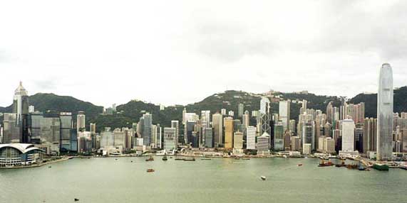
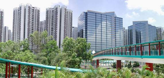
6.3.50 Since this time, successive reclamations across Hong Kong, but particularly on Hong Kong Island and Kowloon have had a dramatic effect on the landscape by significantly increasing the developable area. The continuous urban infill and reclamation from the 1950’s to the present coupled with the construction of high-rise buildings along the Hong Kong harbour front has resulted in Hong Kong’s spectacular urban skyline.
New Towns and Urban Decentralisation
6.3.51 After World War II, a great number of immigrants from the mainland entered Hong Kong, putting enormous pressure on the urban areas and resulting in the presence of extensive squatter settlements sprawling across hillsides, such as those at Shek Kip Mei, Diamond Hill and Pokfulam. These ad hoc settlements have been visible in the landscape until very recently. There was at the same time, a massive expansion of construction in the urban areas. Indeed, until the mid -20th Century, what was notable about the Hong Kong landscape was the striking dichotomy between urban areas (Victoria and Kowloon) and the rural areas of the New Territories, which were largely as they had been for centuries.
6.3.52 In order to tackle these enormous population pressures, Sir Murray Maclehose announced the new towns programme in 1972, with the objective of re-housing and decentralising much of the population in the new towns such as those at Sha Tin, Fanling/Sheung Shui, Tuen Mun and Tai Po were built on easily developable areas of lowland around the New Territories. This has had a dramatic effect on the lowland landscape of the New Territories both in terms of loss of the traditional landscape and in terms of its urbanisation.
6.3.53 The dramatic landscape changes in the New Territories landscape included the construction of reservoirs, reforestation programmes, the proliferation of open storage yards and new towns development.
6.3.54 A characteristic pattern of post-war landscape change is that of Tin Shui Wai, until the 1920s, an area of swamp and marsh, with some salt industry, lime-making and oyster cultivation around the shoreline of Deep Bay. After World War II, the swamp and marsh was reclaimed as brackish water paddy and gei wai (shrimp cultivation ponds). Later still gei wai were converted to fish ponds. (Irving and Morton 1986), until in the 1980's the whole area was reclaimed and developed as a new development.
Infrastructure Expansion
6.3.55 The growth of Hong Kong over the last 150 years, fuelled by its more or less continuous economic growth and concomitant increase in population, has put huge pressure on infrastructure to keep up with this growth. This in turn has dramatically affected the landscapes of the urban fringe and rural fringe where much of this infrastructure is inevitably located.
6.3.56 The British began the process of developing a strategic transportation infrastructure with the construction of military roads linking strategic points in Hong Kong, including the road around Hong Kong Island and Route TWISK. This was accompanied by the construction of the Kowloon Canton Railway in 1910 and the completion of Kai Tak Airport in 1928.
6.3.57 The growth of the population in the 20th century required increased infrastructure to ensure water supply, power generation and waste disposal. Reservoir construction across Hong Kong dramatically transformed the landscapes of rural and urban fringe areas, beginning with Pokfulam Reservoir in 1864. In the cases of the smaller reservoirs such as Aberdeen, Jubilee and Tai Tam Tuk, these diversified the landscape by creating new tranquil aquatic landscapes. In the cases of the larger reservoirs such as High Island and Plover Cove Reservoirs, they have had a dramatic effect on the landscape by transforming what were formerly maritime landscapes into rather different ones.
6.3.58 In the early part of the century a network of military fortifications was constructed across the New Territories, notably at Shing Mun, Stanley and Victoria Peak. The rapid expansion in the population after World War 2 was accompanied by a rapid development in the road and rail transportation network and the construction of a new airport at Chek Lap Kok. The expansion of the transportation network has accelerated in the last 20 years and shows little sign of abating. This has had dramatic impacts on the landscape, not least in the engineering of roads and railways through the landscape and the reduction in the tranquillity and remoteness of certain rural landscapes. This has been accompanied by the presence of a number of significant new bridges in the coastal landscape. Elsewhere the construction of landfills and power stations has transformed the landscapes of parts of the urban fringe.
6.3.59 Finally, urban expansion into lowland areas has reduced the water retention capacity of the floodplains and put pressure on Government to reduce the risk of flooding events. This in turn, has led to a programme of river re-training and canalisation across the New Territories, as well as a simplification of the lowland landscape by eliminating meanders and much associated riparian vegetation.
Rural Depopulation and the Decline of Agriculture
6.3.60 From the 1950s onwards, an increase in economic opportunities in the urban areas and overseas, led to a dramatic decline in the rural population and in traditional rural land use. In certain cases, villages were abandoned or incrementally deserted, particularly in marginal upland areas, and field systems left to revert to scrub. These abandoned landscapes are found across Hong Kong and serve as a telling reminder of its recent landscape history.
6.3.61 Offsetting these effects to a certain extent, were immigrants from the mainland who moved into rural areas. In addition, changes to rural housing policy and planning, mitigated the effects of rural depopulation to a certain extent. However, the long-term trend has been a decline in rural population and in rural land uses, such that by 1980, 40% of all agricultural land was recorded as abandoned and of the remaining 60%, less that 1% was under rice production (Stokes, 1995). Much abandoned agricultural land has been replaced by ad hoc uses requiring little or no capital investment, such as container storage, vehicle parking, scrap yards, or dumping. There has also been an expansion of village housing and increase in residential development in such areas. The result has been a dramatic change in the appearance of the rural landscape, with the loss of the small scale pattern of fields and enclosures, a fragmentation of land use and development types and changes to the muted hues and colours that once characterised the rural landscape.
The Future - The Landscape of the Early 21st Century
6.3.62 Whilst it is not possible to predict exactly what the future may hold for the landscape Hong Kong, a number of economic, policy and development trends have begun to manifest themselves over recent years, which suggest key changes likely to take place in the landscape in the coming decade. These are discussed briefly below.
Transportation Infrastructure
6.3.63 As Hong Kong seeks to integrate more closely with the PRC, a policy seen as a key pillar for continued economic development, significant development of new transportation infrastructure is anticipated. Ongoing or planned projects include the Deep Bay Link, Tung Chung Road Improvement, Shenzhen Western Crossing, Hong Kong-Macau-Zhuhai Link, KCR Lok Ma Chau Spur Line; KCR Kowloon Southern Link; KCR Northern Link, KCR Shatin to Central Link and possible MTR South Hong Kong Island Line. Bearing in mind how much transportation infrastructure has been completed in the last 10 years, this represents a continuation in the influence of such features in the landscape of Hong Kong. Unfortunately, such development is inevitably linear in nature and tends to have the effect of fragmenting and compartmentalising the landscape and disrupting its pattern and linkages. How such development can be integrated into the landscape will be a key challenge for the future.
Natural and Built Heritage Conservation
6.3.64 Recent events suggest an increased awareness on the part of the Hong Kong public and the Government of conservation of both the natural and built environment. This has manifested itself in the public debate and Government action on a number of historic buildings threatened by development as well as Government consultation papers on conservation of the natural and built environment. A number of key studies are also being carried out by Government in order to ascertain the extent of landscape resources. These include the Wetland Compensation Study (AFCD) and the Study on Landscape Value Mapping of Hong Kong (Planning Department).
6.3.65 This renewed public and Governmental interest in the conservation of what are in essence landscape resources, if translated into tangible policy initiatives, may serve to direct the future of landscape resources and features which add to the diversity, character and local distinctiveness of both urban and rural landscapes.
Reclamation Policy
6.3.66 Recent public debate and judicial ruling over the extent of reclamation permissible by law has focused public and Governmental thought on the extent to which reclamation can legitimately continue, at least in Kowloon and Hong Kong, without irredeemably affecting the key relationship between land and sea which makes up the character of this unique landscape.
6.3.67 The manner in which future reclamation is handled in the near future will have a significant bearing on the quality of the urban landscape of the Hong Kong / Kowloon waterfront and of Victoria Harbour. Whether such development can be managed and designed in ways which respect and pay adequate regard to the context and unique landscape character of Victoria Harbour is a key challenge for the coming decade.
Reduction of Height Restrictions in Kowloon
6.3.68 With the closure of Kai Tak airport in 1998, air navigation constraints which had previously restricted the height to which buildings could be developed on the Kowloon Peninsula were removed. Already a number of high-rise buildings have been developed on the Peninsula, representing a marked contrast with the predominant building form that was until recently characteristic of the area.
6.3.69 The manner in which the reduction of height restrictions is managed in the future will determine whether Kowloon retains one of the urban morphological characteristics which has determined in large part, the character of its urban landscape or whether it is allowed to change and develop incrementally into an urban landscape of a different character.
The Landscape of Lantau Island
6.3.70 The landscape of Lantau Island is probably that which has been most significantly changed over the last 15 years. The development of Discovery Bay; the Hong Kong International Airport at Chek Lap Kok; Tung Chung new town development; North Lantau Expressway; and Tsing Ma Bridge are all major projects implemented in the last two decades. A number of other major projects were ongoing or in the planning, feasibility or construction stage at the time of the completion of the PLCM survey in 2003. These included the Disneyland theme park at Penny’s Bay, Hong Kong-Macau-Zhuhai Link; Logistic Park, Tung Chung Road; Port Development and Prison at Hei Ling Chau / Silvermine Bay. Other development projects in southern Lantau have been mooted and discussed in the press, including retail and tourism-related uses.
6.3.71 As Hong Kong's largest Island and one of its least developed landscapes, Lantau Island is in many senses unique. It appears that, with incremental development, it may shortly reach a point at which its capacity to absorb development without compromising its essential character is exceeded.
New Towns and Development Areas
6.3.72 Whilst the first wave of new towns are now all complete, the need to house a population which is predicted to increase necessitates the construction of new developments and new development areas both in urban areas and beyond the urban fringe. These include the completion of the latter phases of the Tin Shui Wai, Tseung Kwan O and North Lantau Developments, the design and construction of the West Kowloon Cultural District and South-east Kowloon Development and proposed developments in the NENT.
6.3.73 Such developments are often located in Hong Kong's former agrarian lowlands and have dramatic implications for these landscapes. Whilst the need to house an ever increasing population seems unavoidable, the manner in which such developments achieve a good fit with their landscape context and the extent to which they can avoid standardised urban design and landscape design solutions and achieve a high quality of urban landscape seems to be one of the most significant challenges for the urban landscape in the next decade.
Hill Fire and Upland Landscape
6.3.74 Hill fires remain the single largest issue preventing natural vegetation succession in the Hong Kong upland landscape. A disaster in ecological terms, they have huge impacts on the landscape contributing to erosion and soil loss which in turn impedes vegetation development. They also probably favour colonisation by non-native species, thus subtly changing the look of the landscape, but having larger ramifications for its ecology.
6.3.75 Contrary to popular opinion, almost every hill fire has a human cause and sadly the sheer numbers of hill fires and the relatively low human death toll seem to trivialise them in the public imagination. Until the public as a whole comes to regard hill fire as the natural disasters that they are, the natural development and succession of the Hong Kong upland landscape will certainly be impeded.
The Closed Area
6.3.76 Recently, there has been some discussion by Government and the public as to the potential to develop part of the Closed Area adjacent to the border with the Mainland, in order to foster economic activity and growth. The low-lying parts of the central Closed Area constitute some of the more intact areas of the remnant lowland Hong Kong landscape and significant development in these areas is likely to have consequent effects for these landscapes.
6.4 OVERVIEW OF THE LANDSCAPE CHARACTER OF HONG KONG
Introduction
6.4.1 Hong Kong's landscape may be conveniently divided into eight broad areas which are distinguished largely by their underlying geology and by insulation. These eight areas are all extremely diverse and are described below and mapped in Figure 6.1.
Hong Kong Island
Landscape Character
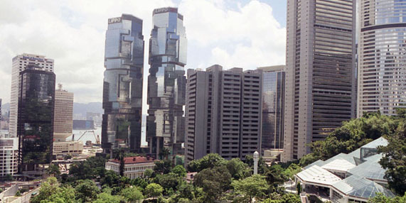
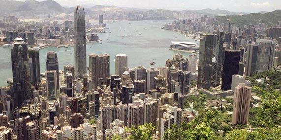
6.4.2 Hong Kong Island, like its underlying geology, is a landscape of two halves. The southern parts of the Island lie on volcanic tuffs forming a series of high peaks which fall steeply to the coast in a series of bays and headlands, notably at Cape D'Aguilar and Chung Hom Kok. These areas are comparatively unpopulated with a significant settlement at Aberdeen and large villages at Stanley and Shek O. By contrast, the northern part of the Island lies on granitic rock and where the two rocks meet in the centre of the island, a steep ridge of hills is formed which includes Victoria Peak (552mPD), Mount Parker (532mPD) and Mount Kellett (501mPD). At the foot of these hills lies the urban area of Hong Kong Island which forms a long ribbon of development along the north shore of the island. Older urban areas lie on the foothills and are characterised by narrow streets which wind up and across hills, as well as relatively high densities of older and historic buildings. Much land has been reclaimed along the seashore on which more recent urban areas have been developed, often to very high densities, for commercial and residential purposes. The combined effect is one of the most spectacular urban landscapes in the world.
Figure 6.2 Central/Wanchai, Hong Kong Island
Key Landscape Characteristics
Central spine of large scale, steep and rolling scrub-covered uplands interspersed by small wooded valleys, narrow rocky streams, reservoirs and winding tracks. Dominated by Victoria Peak, the highest peak on the Island.
In the south and east, precipitous coastal landscapes forming a series of dramatic bays and headlands, with isolated settlements such as those at Stanley, Shek O and Repulse Bay.
Older urban landscapes on the hillsides of north Hong Kong Island at Western District, Sheung Wan, Central and Wanchai, consisting of narrow streets winding across and up hillsides with dense mixed use development, with a relatively high incidence of historic buildings.
More recent urban landscapes situated on flat, low lying reclamation. Much of this is medium rise mixed-use development, but in the commercial corridor between Sheung Wan and Causeway Bay is found one of the most spectacular high-rise urban landscapes in the world, with a number of examples of world-class architecture.
Significant urban open spaces in the heart of the urban area, including Hong Kong Park, the Hong Kong Zoological & Botanical Gardens, Victoria Park and Happy Valley Racecourse.
On the south, west and east coasts, isolated pockets of development in bays and inlets, notably at Aberdeen, Repulse Bay, Stanley and Shek O.
The former fishing settlement of Aberdeen lying on the south coast of the island. Now expanded and in effect joined with the island of Ap Lei Chau, it comprises industrial and port uses as well as extensive residential areas.
Lantau Island
Landscape Character
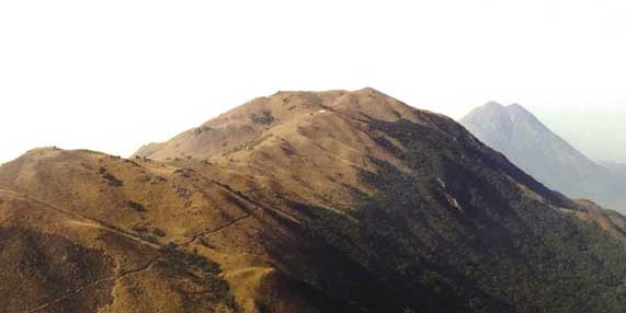
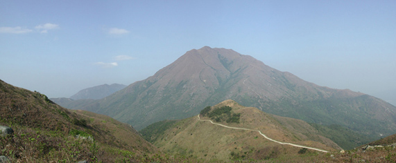
6.4.3 The landscape of Lantau Island is a mountainous island landscape characterised largely by its high exposed peaks and its dramatic and remote coasts. This landscape is defined to a large extent by the two distinct sets of rock on which it lies. The west of the island lies on volcanic tuffs which rise dramatically from the sea to form dramatic craggy peaks (particularly at Sunset Peak and Lantau Peak). These uplands possess a particularly distinctive verticality and grandeur sweeping down smoothly to the coast. By contrast, the east of the island lies on granitic rock which forms lower and more rounded rolling uplands. Whilst woodland and scrub is found in valleys and on lower slopes, the upper slopes of the uplands are largely devoid of vegetation except for grassland. Lantau's character is profoundly influenced by its coastal characteristics and particularly its remote bays, beaches and headlands. Although there has been considerable recent development along the north coast of the island, the remainder of the island remains largely undeveloped except for occasional villages and settlements along the south coast. The western end of the island remains one of the last significant areas of relatively untouched countryside in Hong Kong.
Figure 6.3 Sunset Peak, Lantau Island
Key Landscape Characteristics
Central ridge of high dramatic grass-covered uplands, rising to a peak at Sunset Peak and Lantau Peak. These uplands are steep and dramatic in the west and lower and more rounded in the east. They are almost entirely undeveloped and characterised by narrow incised valleys, tumbling streams, cliffs and boulder fields.
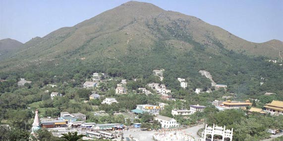
Ngong Ping Plateau, an elevated upland plateau nestling in the peaks and dominated by the giant bronze statue of the Tian Tan Buddha, and one of the most distinctive landscapes in Hong Kong.
Isolated valley landscapes, wooded in upper parts with rocky streams tumbling down them, typically with small settlements on the floor, though fields and houses are often totally or partly abandoned.
Occasional settlements (traditionally with stone-built dwellings) such as Pui O and Mui Wo lie along the coasts of the island, and linked in some cases by Lantau's limited road network.
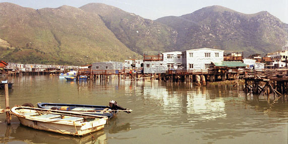
The former fishing village of Tai O, which retains its extensive area of stone built wooden houses built on stilts above the water and which forms one of the most distinctive landscapes in Hong Kong.
Spectacular coastal landscapes falling precipitously into the sea at cliffs and rocky shores, particularly at the western end of Lantau Island, where the landscape is largely undeveloped and possesses a distinct sense of remoteness and tranquillity.
Isolated beaches, sand bars and inter-tidal bays are found around the island, formed by the deposition of material carried down from uplands.
The Hong Kong International Airport at Chek Lap Kok, built on an island largely reclaimed from the sea, the new development at Tung Chung and the North Lantau Highway, together dominate much of the north side of the island.
South-east New Territories
Landscape Character
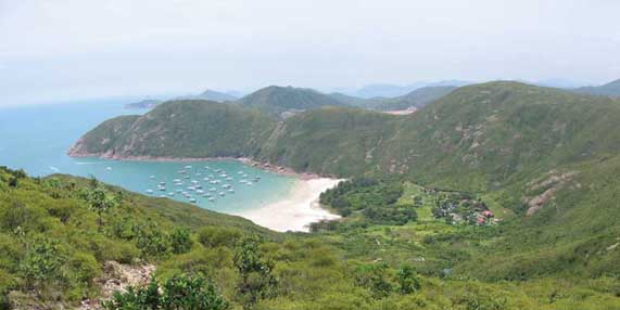
6.4.4 The landscape of the South-east New Territories is a mountainous and largely coastal one, which lies mainly on volcanic rocks forced upwards by geological action to forms high, steep peaks. These have weathered in many cases into jagged angular forms, such as those at Ma On Shan, Pyramid Hill and Sharp Peak. These uplands support little significant vegetation and fall precipitously to a rocky indented coast, characterised by its spectacular coastal rock formations, of cliffs, sea arches and stacks. The numerous offshore islands along the coast form a landscape characterised by the complex relationships of land, sea and sky. Due to its mountainous terrain and coastal location, these landscapes are sparsely settled (Sai Kung and Tseung Kwan O are the only settlements of any size) and often retain a distinct sense of remoteness and tranquillity. Isolated villages lie in valleys along the coast and the only significant human feature of any size is the spectacular High Island Reservoir. Only at Tseung Kwan O has there been significant development, with the ongoing construction of the New Town, port and industrial facilities.
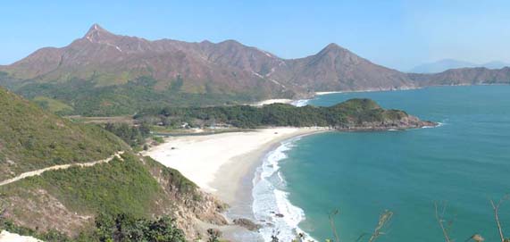
Figure 6.4 Long Ke Wan, Sai Kung, SENT
Key Landscape Characteristics
Dramatic grass-covered uplands, rising to steep rigged peaks such as those at Ma On Shan and Sharp Peak. These uplands are almost entirely undeveloped and possess a distinct sense of remoteness and tranquillity.
Highly weathered tors (standing boulders) and rock forests on the upper parts of uplands, notably on Ma On Shan.
Precipitous coastal landscapes characterised by a series of dramatic bays, headlands and offshore islands. Coastal rock weathers into spectacular cliffs, sea arches and stacks.
Little settlement and limited road network due to the highly isolated nature of the terrain.
A pattern of isolated valley landscapes. These are wooded in upper parts with rocky streams tumbling down them, typically with small settlements on the floor (traditionally stone-built dwellings) though fields and houses are often totally or partly abandoned.
The coastal strip between Clearwater Bay and Sai Kung has been increasingly developed for residential, recreational and other transitional uses.
The new town of Tseung Kwan O and associated reclamation and urban fringe development in Junk Bay.
The North-east New Territories
Landscape Character
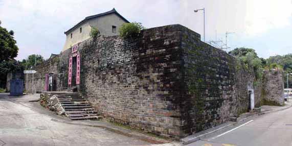
6.4.5 The NENT landscape is one of high uplands and ridges falling in the east to a remote rocky indented coast. The uplands, dominated by the central mass of Tai Mo Shan, Hong Kong's highest mountain, are separated by wide alluvial valleys formed along north-west and north-east trending geological faults. The volcanic tuffs on which the uplands lie form rugged dramatic peak and ridge landscapes, as at Pat Sin Leng and Wong Leng (639mPD). In the east, there are rolling uplands which fall to tranquil coasts characterised by remote valleys, rocky headlands and offshore islands, typified by the landscape of Double Haven. These striking remote landscapes are characterised by the relationships of land, sea and sky as well as by their striking coastal rock formations. By contrast, the wide alluvial valleys to the west comprise comfortable lowland landscapes. Formed by sediments washed down valleys and flood plains, they were until recently, fertile small-scale agrarian landscapes, typified by those at Long Valley, Lam Tsuen Valley and Sha Tua Kok Valley. These areas are today undergoing extensive change as agricultural land is increasingly abandoned and land uses such as open storage, railways, flood alleviation projects and residential development become more prevalent. The new towns of Fanling, Sheung Shui and Tai Po lie in these lowland and valley landscapes.
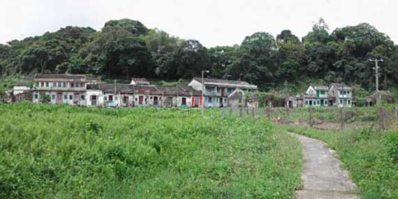
Figure 6.5 Lo Wai, Lung Yeuk Tau, NENT
Key Landscape Characteristics
Dramatic grass-covered uplands, rising to steep rugged peaks and ridges such as those at Pat Sin Leng and Tai Mo Shan. Almost entirely undeveloped, they possess a distinct sense of remoteness and tranquillity.
Tranquil coastal upland landscapes characterised by a series of remote bays, headlands, offshore islands and striking coastal rock features (including sedimentary rock formations, sea arches and sea caves);
Little settlement and limited road network due to the highly isolated nature of the terrain.
A pattern of wide alluvial valleys separating the uplands, trending north-west and north-east, such as the Sha Tau Kok, Fan Kam and Lam Tsuen Valleys. Formerly fertile agrarian landscapes characterised by small scale patterns of villages, fung shui woodland, and fields, this landscape is undergoing change from agriculture to transitional land uses (typically open storage).
Major transportation corridors, such as the KCRC Eastrail, Tolo Highway and Fanling Highway.
New town developments at Fanling / Sheung Shu and Tai Po, together with associated urban fringe development of industrial estates and residential development.
Walled villages ('wai') and traditional rural settlement patterns in the lowland valleys.
Numerous waterways, formerly meandering streams and rivers, many of which have been canalised in recent years for flood prevention purposes.
North-west New Territories
Landscape Character
6.4.6 The NWNT landscape consists of barren granitic uplands in the south and an area of expansive coastal lowlands bordering Deep Bay in the north. The uplands of the south lie on highly weathered granite which forms sets of low rounded uplands and peaks such as those at Castle Peak and at Tai Lam. These uplands are subject to chemical weathering and erosion which results in hillsides being marked by deeply eroded gullies and scars, a phenomenon known as 'badlands'. They therefore support little vegetation and are often barren and undeveloped. To the west, the uplands fall gently to the remote and tranquil coast of Deep Bay. To the north lies a landscape of wide valleys and coastal lowlands, much of it having been extensively reclaimed from Deep Bay over the course of centuries. These landscapes are characterised by fish ponds or gei wai as at San Tin and Mai Po or by arable agriculture in inland areas such as Kam Tin or Pat Heung. Until relatively recently, these were intact agricultural landscapes of fields, small villages and meandering streams. Changes in land use from agriculture or fish farming to open storage and residential development mean it is a landscape in the process of change. This includes development of new towns and developments at Tuen Mun and Tin Shui Wai as well as the gradual loss of traditional rural land uses.
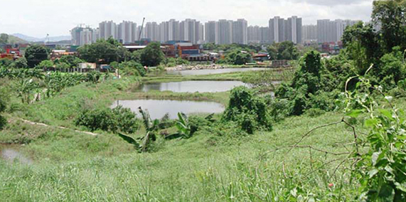
Figure 6.6 Nam Sang Wai and Deep Bay, NWNT
Key Landscape Characteristics
Rolling, barren uplands at Castle Peak and Tai Lam, characterised by high levels of weathering and erosion ('badlands') with limited vegetation cover.
Remote, tranquil coasts between Tuen Mun and Tsim Bei Tsui, characterised by remnant arable fields, small villages and blocks of woodland.
Low-lying coastal landscapes on the edge of Deep Bay, consisting of extensive areas of mudflat, fish pond, gei wai, reed bed and mangrove.
A pattern of wide alluvial valleys and lowlands, separating the uplands, trending north-west and north-east, such as the Kam Tin and Tuen Mun Valleys. Formerly fertile agrarian landscapes characterised by small scale patterns of villages, fung shui woodland, and fields, this landscape is undergoing change from agriculture to transitional land uses (typically open storage).
Major transportation corridors, such as Tuen Mun Road, Castle Peak Road, Route 3, KCRC Westrail and San Tin Highway.
New town developments at Tuen Mun, Tin Shui Wai and Yuen Long, together with associated urban fringe development of industrial estates and residential development.
Walled villages ('wai') and traditional rural village settlement patterns in the lowland valleys.
Numerous waterways, formerly meandering streams and rivers, many of which have been canalised in recent years for flood prevention purposes.
Kowloon/Tsuen Wan/Sha Tin
Landscape Character
6.4.7 The landscape of the Kowloon/Tsuen Wan/Sha Tin area consists of a series of high ridges of granite rock north of Kowloon, together with associated urban development between this ridge and Victoria Harbour. The granites form steep rolling uplands on either side of the Sha Tin Valley and a distinctive ridge of peaks that forms the dramatic backdrop to Kowloon. Below these uplands lies one of the world’s most densely populated urban landscapes, consisting of the Kowloon Peninsula and the urban areas that spread out from it to the west as far as Tsuen Wan and Tsing Yi and to the east as far as Lei Yue Mun. Urban development has been facilitated by extensive areas of reclamation along the coast which now forms medium rise urban landscapes developed to a regular grid of streets and urban blocks in areas such as Sham Shui Po, Yau Ma Tei or To Kwa Wan. The urban landscapes of Kowloon are of widely differing character and quality and include extensive dockside and waterfront landscapes in Kwun Tong and Kwai Chung, low-rise suburban landscapes of Kowloon Tong, vibrant retail streetscapes at Yau Ma Tei and Mongkok and prestigious commercial urban landscapes in Tsim Sha Tsui.
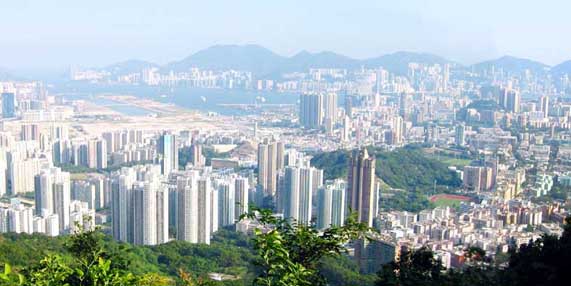
Figure 6.7 Kowloon Peninsula
Key Landscape Characteristics
The Devil's Peak to Golden Hill Ridgeline, an area of rugged granitic uplands characterised by scrub and grass vegetation and limited development save for communications features on peaks.
The Shing Mun Valley where a north-east trending fault has eroded to produce a wide valley with scrub covered hillsides falling from the Shing Mun Reservoirs to Tolo Harbour.
The Kowloon Peninsula forms an undulating spine to the peninsula between Tsim Sha Tsui and Kowloon Tong. It is characterised by rolling topography, low building densities and high incidence of historic buildings, public institutions and open space.
The granitic island of Tsing Yi off the western coast of the Kowloon comprising a steep largely undeveloped upland core with urban and industrial development along its shores.
Extensive reclamation landscapes, situated on the shores of the former Kowloon peninsula reclaimed from Victoria Harbour and generally based on an orthogonal grid, these are some of the most dense and vibrant urban landscapes in Hong Kong.
Major transportation corridors, such as the West Kowloon Expressway, Cross-Harbour Tunnels as well as the Tsing Ma and Ting Kau Bridges.
New towns and new development areas at Tsuen Wan, Kwai Tsing, Tsing Yi and Sha Tin.
Coastal Waters
Landscape Character
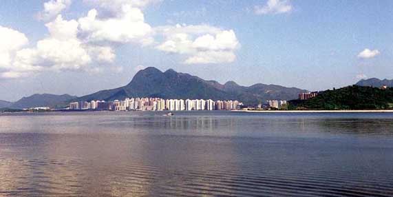
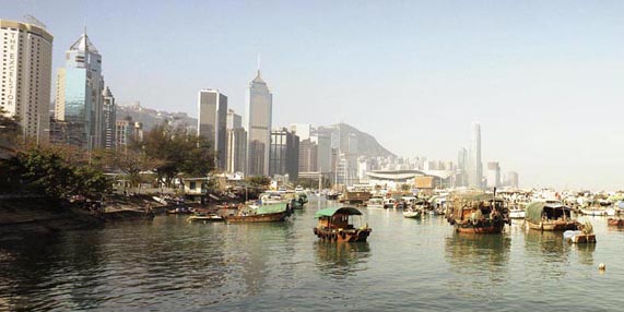
6.4.8 Hong Kong's landscape is defined to a great degree by its complex coastline, patterns of offshore islands and by the resulting relationship between land and sea. Hong Kong's areas of inshore and offshore water are therefore crucial components of its wider 'landscape'. These coastal waters exhibit considerable variety in themselves. They vary from the vast, expansive offshore waters off southern and eastern Hong Kong which possess very few features, to the complex coastal landscapes of bays, headlands and islands in Port Shelter which create a complex and tranquil visual experience. Deep Bay on the other hand forms an enclosed, largely inter-tidal landscape of shallow water and mudflats with a particularly tranquil character. By contrast, Inner Victoria Harbour with its spectacular urban waterfront and vibrant traffic of marine vessels forms one of the most striking coastal landscapes anywhere in the world.
Figure 6.8 The Coastal Waters of Tolo Harbour
Key Landscape Characteristics
Numerous small offshore islands: typically, steep sided, rugged with only a thin covering of scrub and grass.
Coastal bridges, a recent phenomenon in the Hong Kong landscape, including spectacular structures such as the Tsing Ma and Ting Kau bridges.
Fish farms or 'yue pai', a common sight floating off remote coastlines.
Shipping and marine vessels, the most common and significant feature in the coastal landscape, including pleasure craft, fishing vessels, freighters, ferries and ocean-going liners and container ships.
Anchorages, designated moorings for the unloading and loading of vessels, result in striking 'floating landscapes' of ships and their lighters.
Marinas and Typhoon Shelters, dense accumulations of moored vessels in inshore waters are a common site around Hong Kong, whether the prestigious marina at Causeway Bay, the typhoon shelter at Cheung Chau or the extensive marina at Hebe Haven Cove.
Victoria Harbour, one of the most spectacular urban landscapes anywhere in the world, is a product of the relationship of sea, landform and built form.
The Outlying Islands
Landscape Character
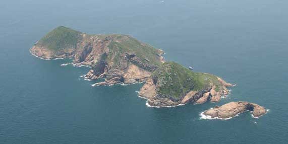
6.4.9 The Outlying Islands include those offshore islands too small to be considered as sub-regions in their own right (such as Lantau or Hong Kong Island) but which are too large to be considered as merely features in the wider coastal waters (such as offshore rocks). As they are widely scattered throughout the coastal waters of Hong Kong, they are found on a variety of different rocks which in turn gives rise to a variety of landscape character. For example, the Outlying Islands in the eastern waters of Hong Kong lie on volcanic tuffs and form rugged islands which rise steeply from the sea, often with dramatic coastal features such as sea arches and sea caves (Tung Lung Chau), cliffs (Basalt Island) or striking geological formations (Ninepin Group). Islands in the southern and western offshore waters lie on granites and are somewhat more rounded with less spectacular coastal formations. These include the Soko Islands, Lung Kwu Chau and Hei Ling Chau. A smaller number of islands in waters off the north-east of Hong Kong lie on sedimentary rock (sandstone, mudstone, siltstone). These islands tend to be fairly low lying and weathered into striking or spectacular coastal formations, such as those at Ma Shi Chau, Port Island and Ping Chau. Only a small number of these islands support a significant population (e.g. Po Toi). However, most of these landscapes share a distinct sense of isolation, exposure, dramatic shorelines and limited vegetation cover. These characteristics, together with their maritime settings make them some of Hong Kong's most striking landscapes.
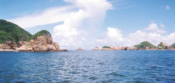
Figure 6.9 The Ninepin Group
Key Landscape Characteristics
A tombolo, or set of joined islands, occurs where longshore drift or tidal action deposits sand between two islands to form a narrow, low-lying area of land between them. Good examples are Ma Shi Chau and Sha Chau.
Sea cliffs, sea arches, sea caves and stacks are dramatic coastal features found primarily on areas of volcanic rock on the eastern shores of Hong Kong.Isolated beaches, such as that at Ping Chau.
Ping Chau, perhaps Hong Kong's most singular landscape by virtue of its unusual sedimentary geology, striking coastal landforms and unusual natural history.
Isolated fishing villages are typical of many outlying islands, such as the small communities at Po Toi and Tung Lung Chau.
Navigational and communications features (such as lighthouse in Wanglan Island and telecommunications structures on Sha Chau and Lung Kwu Chau) and public infrastructure facilities (such as the correctional institution at Hei Ling Chau) are often located on outlying islands.
6.5 DISCUSSION OF DIFFERENT LANDSCAPE TYPES FOUND ACROSS HONG KONG
6.5.1 The following are brief descriptions of the characteristics and coverage of the 6 broad sub-regional landscape types which were defined in the Study, providing an overview of the variety of landscape found in Hong Kong. These landscapes are mapped in Figure 6.10.
Upland Countryside Landscape - The Backbone of Hong Kong’s Landscape
Overview and Context
6.5.2 The majority of Hong Kong’s landscape consists of steep, undeveloped mountains and hills, which fall steeply to the coast. Hong Kong’s uplands form a pattern of ridges and valleys running for the most part, in a northeast to east/north-east direction. This Upland Countryside Landscape dominates the southern, central and eastern New Territories, as well as northern Kowloon, Hong Kong Island and Lantau Island and occupies around 59% of Hong Kong’s land area.
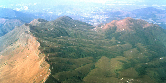
Figure 6.11 Upland Countryside Landscape (Sunset Peak, Lantau Island)
Landscape Character and Components
6.5.3 The Upland Countryside Landscape is generally undeveloped, rugged and tranquil. Above around 300mPD, the uplands consist of craggy peak landscapes. In a small number of cases, flat, elevated upland plateaux landscapes can be found at altitudes above 300mPD.
6.5.4 Between altitudes of 40mPD and 300mPD lie uplands and hillside landscapes which are steep undulating uplands usually covered by scrub and which are predominantly natural and tranquil.
6.5.5 Between these elevated landscapes lie the valley landscapes, often narrow and steep-sided. In some cases, these are unsettled valley landscapes with natural, tranquil, wooded landscapes which have never been developed or inhabited. More usually, they are settled valley landscapes, which take the form of enclosed landscapes of fields, woods, villages and narrow lanes among fields.
Lowland Countryside Landscape - The Settled Rural Landscape
Overview and Context
6.5.6 Because of its dramatic underlying geology, Hong Kong has few natural lowlands below around 40mPD. Even fewer of these retain their traditional rural land uses and landscape features. Such ‘Lowland Countryside Landscapes’ are found in small areas in the South-east and North-east New Territories and on Lantau Island, occupying in total, around 8% of Hong Kong’s land area.
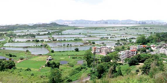
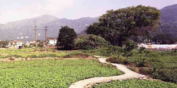
Figure 6.12 Lowland Countryside Landscape (Shek Kong, Yuen Long)
Landscape Character and Components
6.5.7 By far the most extensive area of Lowland Countryside Landscape is found in the North-west New Territories in a belt between Lau Fau Shan and Sha Tau Kok. This area forms an extensive rural coastal plain landscape with a low-lying, open area of land, historically reclaimed from Deep Bay and forming a striking landscape of tightly packed fish ponds interspersed by occasional trees and buildings.
6.5.8 Further inland lie scattered and smaller scale rural inland plain landscapes, consisting of a traditional landscape pattern of low-lying topography, arable fields, ponds, villages, blocks of woodland and winding lanes.
The Rural Fringe Landscape - Rural Landscapes in Transition
Overview and Context
6.5.9 With the changes to the rural economy over the last few decades, many formerly agricultural based rural landscapes have been undergoing gradual change. In such areas, the decline of agricultural activities has led to their replacement by non-rural land uses and features, such as open storage, vehicle parking, golf courses and infrastructure development.
Figure 6.13 Rural Fringe Landscape (Ha Tsuen, Yuen Long)
6.5.10 In these locations, the character of the landscape remains predominantly rural, but there is a perceptible increase of development in the landscape. The ‘Rural Fringe Landscapes’ are found across Hong Kong, but particularly in the lowlands of the North-west and Northern New Territories. They occupy around 10% of Hong Kong’s land area.
Landscape Character and Components
6.5.11 Typically, these landscapes make up a miscellaneous rural fringe landscape with relict agricultural fields, expanding villages and diverse land use (e.g. filling of fish ponds, use of fields for open storage parking or horticulture). This results in a very diverse landscape which, though still essentially rural, has lost some of the qualities that contributed to its previous rural character.
6.5.12 Elsewhere, these ‘Rural Fringe Landscapes’ are created by the flooding of valleys to form reservoir landscapes, or through conversion of lowland areas to provide golf course landscapes.
The Urban Fringe Landscape - The Edges of the City
Overview and Context
6.5.13 At the edges of Hong Kong’s urban areas, are landscapes that contain many urban features and land uses. However, because of their relatively low density of development or by virtue of the presence of remnant rural features, they cannot be considered to be truly urban. These landscapes are found at the edges of the major urban areas of Hong Kong Island and Kowloon and also around new towns in the New Territories and on Lantau Island. They occupy around 10% of Hong Kong’s land area.
Figure 6.14 Urban Fringe Landscape (Shouson Hill, Hong Kong Island South)
Landscape Character and Components
6.5.14 Urban Fringe Landscape’ includes the landscapes associated with institutions (hospitals, colleges or prisons); transportation corridors (consisting of major highways, railways and their associated features); cemeteries; ongoing reclamations and development works as well as landfills and quarries.
6.5.15 Also at the edges of the urban areas, lie suburban residential urban fringe landscapes in the form of low density residential developments set amidst hillsides and green space.
The Urban Landscape - The Landscapes of Town and City
Overview and Context
6.5.16 The proportion of the land area of Hong Kong that is fully urbanised is actually very small and yet these city landscapes are some of the most diverse and memorable of any landscape in Hong Kong. They are found primarily in the major conurbations of Kowloon and northern Hong Kong Island but also across Hong Kong in the new towns of the New Territories and Lantau Island. They occupy around 8% of Hong Kong’s land area.
Figure 6.15 Urban Landscape (Tai Koo Shing, Hong Kong Island)
Landscape Character and Components
6.5.17 On the north shore of Hong Kong Island and the Kowloon Peninsula lie the oldest urban landscapes of Hong Kong, characterised by a dense, irregular and organic urban form, building stock of mixed ages, occasional historic buildings and limited vegetation, forming organic mixed urban development landscapes.
6.5.18 On the reclaimed shores of Hong Kong Island and Kowloon lie commercial urban landscapes, characterised by densely developed prestige architecture such as those in Central or Tsim Sha Tsui. Mid 20th-century urban landscapes such as those of Wanchai, Yau Ma Tei and Shamshuipo are characterised by their diverse land uses, medium rise development of varying ages, rectilinear street grid and relatively limited vegetation forming a city-grid mixed urban landscape.
6.5.19 At the edges of the urban areas, lie extensive residential urban landscapes, consisting of estates of medium and high-rise residential buildings set in communal landscapes or green space.
6.5.20 Other urban areas which possess their own distinctive landscapes include new towns, urban parks, industrial areas, and small townships (such as Stanley and Sai Kung).
The Coastal Waters Landscape - The ‘Seascape’
Overview and Context
6.5.21 Given its coastal location, the sea is a vital component of much of Hong Kong’s landscape and these Coastal Waters Landscapes should not be overlooked. They are characterised predominantly by the presence of water, in combination with other landscape components such as islands and maritime features such as vessels or fish farms. Such landscapes are found along the coast of Hong Kong’s land mass as well as around outlying islands and occupy around 5% of the total land area. The area of water within Hong Kong’s ‘Coastal Waters Landscapes’ is about 1,636km2.
Figure 6.16 Coastal Waters Landscape (Causeway Bay Typhoon Shelter, Hong Kong Island)
Landscape Character and Components
6.5.22 Many of these landscapes take the form of enclosed, tranquil bay landscapes whose only features may be fish farms or occasional small vessels. Many such landscapes can be found around the coast of Hong Kong, particularly in the North-east New Territories.
6.5.23 Between adjacent areas of land or islands, the Coastal Waters Landscapes take the form of straits landscapes, the most striking of which is Victoria Harbour. With its dramatic surrounding mountains, spectacular urban waterfront and bustling maritime activity, Victoria Harbour is one of the most singular coastal landscapes in the world. The protection of vessels moored in areas of inshore waters by seawalls and breakwaters leads to the creation of typhoon shelter landscapes, such as those at Causeway Bay, Aberdeen or Cheung Chau.
6.5.24 Elsewhere, at various locations around the coast of Hong Kong but particularly on the coast of Deep Bay in the North-west New Territories, the deposition of silts forms low lying inter-tidal coast landscapes of mangroves, reed bed or mud flats which are often habitats rich in flora and fauna.
6.5.25 Further offshore, the coastal waters are open and exposed, punctuated only by occasional vessels or by small island landscapes which, when in groups - such as the Sokos or Po Toi Islands - form striking remote sea landscapes.
6.6 DISTINCTIVE LANDSCAPES IN HONG KONG
6.6.1 Hong Kong possesses many landscapes which are particularly distinctive or memorable. Some of these distinctive landscapes are described below.
The Man-made Landscape - The Urban Area of Hong Kong Island and Kowloon
6.6.2 For its compact size, concentration of tall buildings and its immediate relationship with the bustling harbour and mountainous backdrop, the urban area of Hong Kong Island and Kowloon forms one of the most visually dramatic urban landscapes in the world.
Figure 6.17 Admiralty, Hong Kong Island
A Meeting of City, Sea and Mountains - Victoria Harbour
6.6.3 Ringed by mountains, and boasting one of the world’s great urban waterfronts, Victoria Harbour is a unique landscape formed by the juxtaposition of sea, city and hills.
Figure 6.18 Victoria Harbour
6.6.4 The Harbour itself, with its vibrant mixture of marine craft and busy maritime activity adds to the diversity and drama of this landscape. It is perhaps the most immediately memorable landscape image of Hong Kong and one of the most remarkable coastal landscapes anywhere in the world.
Between the Tides - The Coast of the North-west New Territories
6.6.5 The low-lying coastal plain of the North-west New Territories (NWNT) shapes a striking landscape that is almost as much water as it is land. At Nam Sang Wai, Lut Chau and San Tin, areas which are largely reclaimed from the sea, are extensive low-lying landscapes of densely packed fish ponds, whilst along the coasts at Tsim Bei Tsui and Mai Po lie tranquil landscapes of shallow coastal water, mud flats, reed beds, mangrove and gei wai.
Figure 6.19 Lau Fau Shan, Yuen Long
6.6.6 These different features combine to produce a series of coastal landscapes with a serene, remote character, particular sense of place and outstanding wildlife associations, unique in the region.
One of Hong Kong’s Last Areas of Untouched Countryside - West Lantau
6.6.7 The uplands of West Lantau form one of the last areas of virtually untouched countryside in Hong Kong. The steep grass-covered mountains plunge dramatically from their craggy peaks into the Pearl River Estuary. The mountainsides are scattered with cliffs, crags and boulder fields, whilst below these uplands lie intimate stream-lined valleys and monasteries nestling in the hills.
Figure 6.20 Ngong Ping Plateau, Lantau Island
6.6.8 The upland plateau at Ngong Ping is home to the giant bronze statue of the Tian Tan Buddha, the largest of its kind, a key landmark in the Hong Kong landscape. The area offers a landscape that is attractive both for its overwhelmingly natural character and for its scenic qualities.
A Tranquil Shore - The East Coast of the New Territories
6.6.9 The eastern coastline of the New Territories consists of a series of steep volcanic uplands forming angular mountain peaks (such as Sharp Peak or Pyramid Hill) which fall dramatically into the sea, producing spectacular cliffs, rock formations and angular, deserted offshore islands.
Figure 6.21 Tai Long Wan, Sai Kung
6.6.10 All along the coast can be found remote bays, or inlets (such as that at Lo Fu Wat in the Tolo Channel) and isolated beaches (the best known being those at Tai Long Wan in Sai Kung). The Tai Long Wan area is still largely inaccessible and almost free from development, and much of this landscape offers a strong sense of remoteness and natural beauty, an attribute rare in a compact city like Hong Kong.
The Top of Hong Kong - The Peaks of The New Territories
6.6.11 Comprising most of the highest mountains in Hong Kong (including Tai Mo Shan, Ma On Shan and Pat Sin Leng), the major peaks of the New Territories form some of its most spectacular and memorable landscapes.
Figure 6.22 Pak Sin Leng, Tai Po
6.6.12 Above the tree line, these landscapes are generally rugged, remote and exposed and are characterised by short grasses and low scrub, rock outcrops, rock forests and ephemeral streams. Comprising dramatic landscapes characterised by their elevation, remoteness and expansiveness, these areas are as memorable for their dramatic topography and sense of isolation, as for the spectacular views that they offer across the New Territories.
Villages in The Landscape - The Lowlands and Villages of the Northern New Territories
6.6.13 In the North and North-east New Territories are low-lying landscapes in which streams wind through active or abandoned agricultural fields, blocks of woodland and isolated villages, many of which are traditional fortified villages (or ‘wai’).
6.6.14 These villages are connected by lanes which meander through the arable fields that surround them. Whilst this landscape is the subject of much ongoing change in land use (especially disuse of agricultural land and an increase in numbers of storage yards) some areas retain much of their former rural character and this is one of the last places in Hong Kong where the traditional form and relationship of vernacular villages to other rural landscape features can still be experienced.
Figure 6.23 Fung Hang Village, Luk Keng
The Land in the Sea – Hong Kong’s Island Landscapes
6.6.15 The intimate relationship of the land to the sea is one of the key characteristics of the wider Hong Kong landscape. Along Hong Kong's complex coastline can be found hundreds of islands, some little larger than rocks, others supporting significant populations. Many are isolated, alone in the sea whilst others, such as the Soko Islands or Po Toi Islands form scattered groups.
6.6.16 Their remoteness and outlying locations mean that in some cases (notably at Tung Ping Chau) they form unique landscapes, rich in nature conservation interests.
Figure 6.24 The Ninepin Group
6.6.17 They often boast spectacular cliffs and coastal rock formations as well as some of the oldest villages in Hong Kong.
Hong Kong’s Traditional Fishing Village - Tai O
6.6.18 Tai O village at the western end of Lantau Island is one of Hong Kong’s oldest settlements, originally founded on salt production, fishing and sea trade. Situated in a bay in front of a small coastal plain reclaimed from the sea, the village for the most part retains its traditional form and character and is particularly known for its extensive settlement of stilt houses sitting in the water.
Figure 6.25 Tai O, Lantau Island
6.6.19 This fusion of water and built structures is an unique landscape in Hong Kong and forms a distinctive landscape that is important for both its cultural and scenic values.
6.7 ANALYSIS OF FIELD SURVEY DATA
Introduction
6.7.1 This section of the report presents the analysis of the data collected during the Study. Data is analysed as follows:
Analysis of LCT Size and Occurrence;
Analysis of Condition; and
Analysis of Value.
6.7.2 The following is a brief analysis of data gathered on the different landscapes in Hong Kong. This analysis is first by LCT, then by Condition and Value.
Analysis of LCT Size and Occurrence
6.7.3 An analysis of LCT size and occurrence is shown in Table 6.1. Geographical distribution of different LCTs is shown in the Landscape Character Map.
Table 6.1 Analysis of LCTs in LCM
LCT Number of LCAs Smallest LCA(ha) Largest LCA(ha) Average size of LCA Total area covered by LCT (ha) % of total Study area covered by LCT LCAs as % of Total in HK Airport Landscape 1 1,200.5 1,200.5 1,200.5 1,200.5 0.4 0.1 Bay Landscape 19 56.2 1229.8 378.0 7,182.8 2.6 2.0 Cemetery Landscape 8 9.1 234.8 60.2 481.9 0.2 0.8 City Grid Mixed Urban Landscape 14 8.8 143.7 57.4 803.2 0.3 1.5 Civic Urban Waterfront Landscape 3 18.4 66.1 35.7 107.2 <0.1 0.3 Coastal Upland and Hillside Landscape 77 19.6 1067.6 192.3 14,805.6 5.4 8.2 Comprehensive Residential Development Landscape 5 28.2 162.4 97.5 487.4 0.2 0.5 Golf Course Landscape 6 22.5 176.4 110.2 661.5 0.2 0.6 ‘Hui’ Urban Landscape 6 9.5 110.8 34.0 203.8 0.1 0.6 Industrial Urban Landscape 31 8.0 391.0 75.7 2,347.1 0.9 3.3 Inshore Water Landscape 22 284.3 10,015.4 2,068.7 45,511.5 16.5 2.3 Institutional Landscape 26 10.1 118.7 41.2 1,070.3 0.4 2.8 Inter-tidal Coast Landscape 11 5.9 834.2 154.2 1,696.7 0.6 1.2 Island Landscape 38 4.0 368.4.0 76.4 2,903.6 1.1 4.0 Late 20C/Early 21C Commercial /Residential Complex Landscape 8 14.8 80.5 35.0 280.1 0.1 0.8 Low-rise Residential Urban Landscape 1 133.1 133.1 133.1 133.1 <0.1 0.1 Medium / High-rise Commercial Urban Landscape 5 18.0 32.0 26.1 130.3 <0.1 0.5 Miscellaneous Rural Fringe Landscape 27 28.3 655.6 215.8 5,827.5 2.1 2.9 Miscellaneous Urban Fringe Landscape 49 11.3 190.0 65.8 3,224.3 1.2 5.2 Mixed Modern Comprehensive Urban Development Landscape 17 14.8 83.7 43.8 744.4 0.3 1.8 Offshore Water Landscape 5 4,229.1 55,784.0 21,079.8 105,399.1 38.3 0.5 Organic Mixed Urban Development Landscape 6 14.9 190.1 58.2 349.3 0.1 0.6 Park Urban Landscape 18 6.9 80.5 24.1 433.3 0.2 1.9 Peak Landscape 50 9.0 1611.0 202.0 10,100.4 3.7 5.3 Quarry / Landfill Landscape 9 21.3 121.5 55.4 498.5 0.2 1.0 Reclamation / Ongoing Major Development Landscape 15 20.5 370.8 99.5 1,492.8 0.5 1.6 Reservoir Landscape 9 18.6 1,433.7 357.3 3,215.3 1.2 1.0 Residential Urban Fringe Landscape 41 17.3 289.0 74.4 3,051.3 1.1 4.3 Residential Urban Landscape 56 9.6 216.5 60.3 3,375.0 1.2 5.9 Rural Coastal Plain Landscape 30 17.6 541.3 139.3 4,180.2 1.5 3.2 Rural Inland Plain Landscape 18 31.6 719.2 270.5 4,869.1 1.8 1.9 Rural Township Landscape 6 14.1 93.2 38.1 228.8 0.1 0.6 Settled Valley Landscape 124 13.9 637.0 132.7 16,454.3 6.0 13.1 Strait Landscape 6 187.0 1,342.0 782.3 4,693.5 1.7 0.6 Theme Park Landscape 2 18.6 48.8 33.7 67.4 <0.1 0.2 Transportation Corridor Landscape 7 27.4 351.0 117.0 818.7 0.3 0.7 Typhoon Shelter Landscape 11 18.8 142.4 59.2 650.7 0.2 1.2 Unsettled Valley Landscape 29 22.9 401.7 101.0 2,902.8 1.1 3.1 Upland Plateau Landscape 9 44.7 92.4 64.5 580.3 0.2 1.0 Upland and Hillside Landscape 106 27.1 733.0 204.1 21,631.5 7.9 11.2 Urban Peripheral Village Landscape 12 14.1 161.7 62.1 745.7 0.3 1.3 Total 943 N/A N/A N/A 249,700.00 100 100 6.7.4 The most numerous LCTs are Settled Valley Landscape (124) followed by Upland and Hillside Landscape (106). The number of Settled Valley Landscape reflects their compartmentalisation and relatively small size. The number of Upland and Hillside Landscape LCTs on the other hand is a reflection of the very large area of Hong Kong covered by this landscape type.
6.7.5 The least numerous LCTs are Airport Landscape (1) at Chek Lap Kok; Low-rise Residential Urban Landscape (1) at Kowloon Tong and Theme Park Landscape (2) comprising the upper and lower parts of Ocean Park (at the time of Completion of the survey in 2003).
6.7.6 The smallest LCTs on average are Park Urban Landscape (24ha) followed by Medium / High-rise Commercial Urban Landscape (26 ha) and Theme Park Landscape (33 ha). The largest LCTs on average are Offshore Water Landscape (21,079 ha) followed by Inshore Water Landscape (2,068 ha) and Airport Landscape (1,200 ha).
6.7.7 Corresponding to the above data, the LCTs which have the greatest coverage in terms of total area are Offshore Water Landscape (over 105,399 ha or 38% of the Study area) followed by Inshore Water Landscape (45,511 ha or 16% of the Study area) and Upland and Hillside Landscape (over 21,631 ha or 7.9% of the Study area). The LCTs covering the smallest area of Hong Kong are Theme Park Landscape (67 ha or less than 0.1% of Hong Kong) followed by Civic Urban Waterfront Landscape (107 ha or 0.1% of Hong Kong) and Medium / High-rise Commercial Urban Landscape (130 ha or 0.1% of Hong Kong).
Analysis of Condition
6.7.8 Table 6.2 sets out the numbers of LCAs falling into the categories of Good, Moderate and Poor Condition in the Final LCM.
Table 6.2 Overall Analysis of Condition of LCAs in LCM
LCA Condition Number % of Total Number Good 720 76.3 Moderate 167 17.7 Poor 56 6.0 Total 943 100 6.7.9 In terms of numbers, the vast majority of Hong Kong's landscapes (76%) are in Good Condition, with only some 6% in Poor Condition.
Condition and Landscape Character Type
6.7.10 Table 6.3 shows a breakdown of Condition for each LCT in the Final LCM.
Table 6.3 Analysis of Condition of LCTs in LCM
LCT Total Number of LCAs LCAs in Good Condition LCAs in Moderate Condition LCAs in Poor Condition Airport Landscape 1 0 1 0 Bay Landscape 19 19 0 0 Cemetery Landscape 8 0 2 6 City Grid Mixed Urban Landscape 14 0 10 0 Civic Urban Waterfront Landscape 3 1 2 0 Coastal Upland and Hillside Landscape 77 75 2 0 Comprehensive Residential Development Landscape 5 1 4 0 Golf Course Landscape 6 6 0 0 ‘Hui’ Urban Landscape 6 0 6 0 Industrial Urban Landscape 31 0 9 22 Inshore Water Landscape 22 22 0 0 Institutional Landscape 26 20 6 0 Inter-tidal Coast Landscape 11 11 0 0 Island Landscape 38 36 0 2 Late 20C/Early 21C Commercial /Residential Complex Landscape 8 0 8 0 Low-rise Residential Urban Landscape 1 1 0 0 Medium / High-rise Commercial Urban Landscape 5 1 4 0 Miscellaneous Rural Fringe Landscape 27 26 1 0 Miscellaneous Urban Fringe Landscape 49 25 20 4 Mixed Modern Comprehensive Urban Development Landscape 17 1 16 0 Offshore Water Landscape 5 5 0 0 Organic Mixed Urban Development Landscape 6 5 1 0 Park Urban Landscape 18 18 0 0 Peak Landscape 50 50 0 0 Quarry / Landfill Landscape 9 0 0 9 Reclamation / Ongoing Major Development Landscape 15 0 3 12 Reservoir Landscape 9 9 0 0 Residential Urban Fringe Landscape 41 38 3 0 Residential Urban Landscape 56 4 52 0 Rural Coastal Plain Landscape 30 30 0 0 Rural Inland Plain Landscape 18 18 0 0 Rural Township Landscape 6 1 5 0 Settled Valley Landscape 124 123 1 0 Strait Landscape 6 6 0 0 Theme Park Landscape 2 2 0 0 Transportation Corridor Landscape 7 0 6 1 Typhoon Shelter Landscape 11 10 1 0 Unsettled Valley Landscape 29 29 0 0 Upland Plateau Landscape 9 9 0 0 Upland and Hillside Landscape 106 106 0 0 Urban Peripheral Village Landscape 12 12 0 0 Total 943 720 167 56 6.7.11 As the analysis of Condition reflects the integrity of natural landscape features, one might expect a consistent correlation between urban landscapes and Poor Condition. This is principally because the scale and type of development prevalent in Hong Kong rarely allows for the integrity of natural topography to maintained but rather requires extensive terracing and slope regrading. This therefore affects the fundamental condition of the landscape. It is important to realise however that this correlation is not a necessary one and that sensitive small scale development is perfectly able to accommodate and reflect topography, whilst retaining vegetation in situ. This is however, rarely the case in Hong Kong. LCTs that are almost always in Good Condition include Upland and Hillside Landscape; Coastal Upland and Hillside Landscape, Peak Landscape; Settled Valley Landscape and Unsettled Valley Landscape, Island Landscape as well as Rural Inland Plain Landscape and Rural Coastal Plain Landscape.
6.7.12 Older urban areas from the middle part of the last century such as City Grid Mixed Urban Landscape are typically only in Moderate Condition, mainly because they have no natural landform (being generally on reclamation) and only very limited vegetation coverage. This contrasts with many older Organic Mixed Urban Development Landscape where relatively high levels of topographic and vegetation coverage remain and where levels of Condition are correspondingly higher. The urban LCT that is consistently in poorest Condition is Industrial Urban Landscape, on account of their heavily altered or artificial topography and almost total absence of vegetation cover.
6.7.13 Conversely, there is a striking relationship between rural landscapes and landscape Condition, with the majority of such LCTs being in Good Condition and few in Moderate Condition. No rural LCAs are in Poor Condition. Urban Fringe and Rural Fringe LCAs typically exhibit a range of Conditions, with Cemetery Landscape almost always being in Poor Condition (due to their highly amended landform and limited vegetation cover) and Golf Course Landscape always being in Good Condition due to their largely natural topography and ample vegetation cover.
Spatial Distribution of Landscape Condition
6.7.14 The spatial distribution of landscape Condition largely reflects the characteristics noted above. Urban areas on Hong Kong Island, Kowloon, Shatin, Tuen Mun, Tung Chung, Tseung Kwan O, Tai Po and Fanling/Sheung Shui are typically in Moderate Condition. Landscapes in Poor Condition occur principally on the fringes of these urban areas.
6.7.15 On the other hand, landscapes in Good Condition tend to be those that are in rural and predominantly upland areas as well as on the non-urban coasts, particularly Hong Kong Island south, SENT, southern Lantau, the central NT uplands and NENT.
6.7.16 The NWNT and northern central NT have a much higher incidence of Moderate and Poor Condition landscapes, mainly because they are lower lying and hence more easily adapted for development. The spatial disposition of landscape Condition across Hong Kong is shown in Figure 6.26.
Analysis of Value
6.7.17 Table 6.4 sets out the numbers of LCAs falling into different Value classes in the Final LCM.
Table 6.4 Analysis of Value of LCAs in LCM (terrestrial and marine LCAs)
LCA Value Number % of Total Number High Value 446 47.30 High(Q) Value 221 23.43 Moderate 233 24.71 Low 43 4.56 Total 943 100 6.7.18 In terms of numbers, almost half of Hong Kong's LCAs (47.30%) can be described as being of High Value with some 23.43% being of High (Qualified) value. Around a quarter of landscapes (24.71%) are of Moderate value with a very small percentage (under 5%) being of Low Value.
Value and Landscape Character Type
6.7.19 Table 6.5 sets out a breakdown of Value for each LCT in the Final LCM. Landscape value represents the importance we attach to a landscape and is attributed taking into account visual coherence, complexity, rarity, relief and condition, key heritage/natural features and visual attractor/detractor. In the study, landscape value is ranked as either ‘High’, ‘High (Qualified)’, ‘Moderate’ or ‘Low’. Their distributions are shown in Figure 6.27.
Table 6.5 Analysis of Value of LCTs in LCM
LCT Total Number of LCAs LCAs with High Value LCAs with High(Q) Value LCAs with Moderate Value LCAs with Low Value Airport Landscape 1 0 0 1 0 Bay Landscape 19 18 1 0 0 Cemetery Landscape 8 0 0 8 0 City Grid Mixed Urban Landscape 14 0 2 12 0 Civic Urban Waterfront Landscape 3 1 0 2 0 Coastal Upland and Hillside Landscape 77 72 3 2 0 Comprehensive Residential Development Landscape 5 0 5 0 0 Golf Course Landscape 6 5 0 1 0 ‘Hui’ Urban Landscape 6 0 6 0 0 Industrial Urban Landscape 31 0 0 11 20 Inshore Water Landscape 22 22 0 0 0 Institutional Landscape 26 3 14 9 0 Inter-tidal Coast Landscape 11 10 1 0 0 Island Landscape 38 33 3 2 0 Late 20C/Early 21C Commercial /Residential Complex Landscape 8 0 2 6 0 Low-rise Residential Urban Landscape 1 0 1 0 0 Medium / High-rise Commercial Urban Landscape 5 0 4 1 0 Miscellaneous Rural Fringe Landscape 27 1 5 21 0 Miscellaneous Urban Fringe Landscape 49 0 13 34 2 Mixed Modern Comprehensive Urban Development Landscape 17 0 1 16 0 Offshore Water Landscape 5 5 0 0 0 Organic Mixed Urban Development Landscape 6 0 6 0 0 Park Urban Landscape 18 18 0 0 0 Peak Landscape 50 49 1 0 0 Quarry / Landfill Landscape 9 0 0 0 9 Reclamation / Ongoing Major Development Landscape 15 0 0 4 11 Reservoir Landscape 9 9 0 0 0 Residential Urban Fringe Landscape 41 2 30 9 0 Residential Urban Landscape 56 0 3 53 0 Rural Coastal Plain Landscape 30 14 14 2 0 Rural Inland Plain Landscape 18 2 7 9 0 Rural Township Landscape 6 1 2 3 0 Settled Valley Landscape 124 53 58 13 0 Strait Landscape 6 5 1 0 0 Theme Park Landscape 2 0 2 0 0 Transportation Corridor Landscape 7 0 0 6 1 Typhoon Shelter Landscape 11 0 11 0 0 Unsettled Valley Landscape 29 25 4 0 0 Upland Plateau Landscape 9 5 4 0 0 Upland and Hillside Landscape 106 93 12 1 0 Urban Peripheral Village Landscape 12 0 5 7 0 Total 943 446 221 233 43 6.7.20 TThe spatial disposition of landscape Value across Hong Kong is shown in Figure 6.27. The Study shows that (including Coastal Waters) almost 83% of the area of Hong Kong is of High landscape Value. High Value landscapes are typically found in rural, upland and coastal areas. In these areas, there are high levels of visual coherence, complementary patterns of natural features and often a distinct sense of place. They are also found in urban areas, but are less common there, usually because of an unsatisfactory relationship between man-made and natural landscape features, preponderance of generic development types or limited spatial diversity diminishes visual coherence and sense of place. Large areas of the SENT, NENT, central NT, Lantau Island and central Hong Kong Island fall into this category.
6.7.21 Approximately 8% of the area of Hong Kong is of High(Q) landscape value. High(Q) Value landscapes are found typically in rural lowland areas as well as in the rural fringe and urban fringe. In such cases, the typical pattern of landscape features has usually been disturbed or altered by incremental changes in land use or development, such as the abandoning of agricultural land use and the intrusion of non-rural land uses such as open storage. High(Q) Value landscapes are also found in urban areas where there is a coherent relationship between man-made and natural landscape features, where the variety, scale and pattern of development is coherent and where there is a particular sense of place and character. High(Q) Value landscapes are found across Hong Kong, most typically on the foothills or lowland areas of the NWNT, northern and central NT, SENT and Hong Kong Island.
6.7.22 Approximately 8% of the area of Hong Kong is of Moderate landscape Value. Moderate Value landscapes predominate on the fringes of the urban areas and in inner city areas. Such landscapes may be regarded as Hong Kong's 'ordinary' landscapes and typically have a limited relationship between man-made and natural landscape features, a preponderance of generic developments types, limited spatial diversity, visual coherence and no outstanding sense of place. Such landscapes are found typically across the Kowloon to Tsuen Wan conurbation, on the urban area on the north shore of Hong Kong Island and in many of the new towns.
6.7.23 There are relatively few areas of Low Value landscape in Hong Kong (just over 1% of the total area of the HKSAR). Such landscape tends to be located on the urban or rural fringes. They tend to occur only where the integrity or pattern of the landscape has been totally destroyed and where specific features significantly detract from the visual coherence of the landscape. Landscapes which typically fall into the Low Value category include landfills, quarries and ongoing reclamation. There is a high number of such landscapes on the shore and fringes of the Tsuen Wan-Lei Yue Mun conurbation, due to the presence of industrial development and ongoing reclamations/developments.
Analysis of Rarity
6.7.24 An analysis of rarity of Landscape Character Types is provided in Table 6.6. This was carried out by identifying LCTs which occur only infrequently in Hong Kong (i.e. less than 1% by number of all LCAs in Hong Kong) and those which are unique (i.e. the only examples of the LCT in Hong Kong).
6.7.25 The two Unique LCTs in Hong Kong are the Airport Landscape at Chek Lap Kok and the Low-rise Residential Urban Landscape at Kowloon Tong. Infrequent LCTs include Cemetery Landscape; Civic Urban Waterfront Landscape; ‘Hui’ Urban Landscape; Comprehensive Residential Development Landscape; Golf Course Landscape; Late 20C/Early 21C High-rise Commercial/Residential Complex Landscape; Medium / High-rise Commercial Urban Landscape; Offshore Water Landscape; Organic Mixed Urban Development Landscape; Quarry / Landfill Landscape; Reservoir Landscape; Rural Township Landscape; Strait Landscape; Theme Park Landscape; Transportation Corridor Landscape and Upland Plateau Landscape.
Table 6.6 Rarity of Landscape Character Types
LCT Total Number of LCAs Unique Infrequent Airport Landscape 1 X Bay Landscape 19 Cemetery Landscape 8 X City Grid Mixed Urban Landscape 14 Civic Urban Waterfront Landscape 3 X Coastal Upland and Hillside Landscape 77 Comprehensive Residential Development Landscape 5 X Golf Course Landscape 6 X ‘Hui’ Urban Landscape 6 X Industrial Urban Landscape 31 Inshore Water Landscape 22 Institutional Landscape 26 Inter-tidal Coast Landscape 11 Island Landscape 38 Late 20C/Early 21C Commercial /Residential Complex Landscape 8 X Low-rise Residential Urban Landscape 1 X Medium / High-rise Commercial Urban Landscape 5 X Miscellaneous Rural Fringe Landscape 27 Miscellaneous Urban Fringe Landscape 49 Mixed Modern Comprehensive Urban Development Landscape 17 Offshore Water Landscape 4 X Organic Mixed Urban Development Landscape 6 X Park Urban Landscape 18 Peak Landscape 50 Quarry / Landfill Landscape 9 X Reclamation / Ongoing Major Development Landscape 15 Reservoir Landscape 9 X Residential Urban Fringe Landscape 41 Residential Urban Landscape 56 Rural Coastal Plain Landscape 30 Rural Inland Plain Landscape 18 Rural Township Landscape 6 X Settled Valley Landscape 124 Strait Landscape 6 1 Theme Park Landscape 2 2 Transportation Corridor Landscape 7 0 Typhoon Shelter Landscape 11 Unsettled Valley Landscape 29 Upland Plateau Landscape 9 Upland and Hillside Landscape 106 X Urban Peripheral Village Landscape 12