5.1 INTRODUCTION
5.1.1 This Chapter of the report sets out the Field Survey Method employed during the Study. This method was first tested in a Pilot Survey of Lantau Island and refined in the light of that experience. This Chapter of the Report addresses in particular:
Surveying Process;
Organisation of Survey Teams;
Field Data Records;
Methods for Minimising Subjectivity and Ensuring Consistency of Field Survey;
Technical Instrumentation; and
Transport and Logistics.
5.2 SURVEYING PROCESS
5.2.1 The Field Survey process began with a briefing on the preliminary classification system and the Preliminary Landscape Character Map. This was followed by a thorough briefing to the survey team on the field survey methodology to be used and instruction in the use of GPS-linked cameras.
5.2.2 After completion of a small number of LCA surveys, a de-briefing and analysis of results was carried out in order to get feedback on refine record systems and the methodology and/or Preliminary Landscape Character Map and classification system. The Survey then proceeded.
5.2.3 For each LCA, the following key tasks were completed:
select a Field Record Station;
complete a Field Data Record (including observations on Description; Evaluation; Trend and Management);
make a photographic record at the Field Record Station;
refine/confirm the boundaries of LCAs/LCTs;
refine/confirm the classification of LCA; and
add where necessary, new LCTs to the classification system.
5.2.4 In a small number of LCAs, it proved impossible to identify a Field Record Station within the LCA itself due to access problems, particularly in remote uplands. In these cases, the survey was carried out from just outside the LCA or from a helicopter, which proved to be a reasonable, practicable method.
5.2.5 Where access was possible, survey teams carried out a general walkover survey of each LCA to adjust the boundaries. During this process, they also identified the location (Field Record Station) from which to take a representative photo of the LCA.
5.2.6 A Field Data Record was completed at the Field Record Station chosen for each LCA, reflecting the characteristics of the LCA as a whole and not just those visible from the Field Record Station.
5.2.7 Finally, all data gaps were identified and a series of helicopter flights planned with the agreement of Planning Department, so that areas not accessible on the ground could be surveyed.
5.3 SURVEY TEAMS
5.3.1 Two survey teams were deployed each comprising two members:
One Senior Landscape Designer with at least 5 years' experience of working and living in Hong Kong; and
One Assistant Landscape Designer.
5.3.2 Having two team members in each team proved useful both for reaching a consensus on matters such as evaluation and classification, but also in terms of transporting all necessary equipment (GPS/camera, hand-held PC, map, water, food, etc).
5.3.3 Communication with two teams out in the field was challenging although manageable. In particular, it was important to communicate the many adjustments of emphasis or methodology that took place during the Pilot Survey and write-up to all 4 team members equally. Had there been more teams or team members, the simple process of communicating with all members would probably have proved prohibitive.
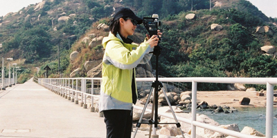
Figure 5.1 Field Surveyor on Site
5.4 FIELD DATA RECORDS
5.4.1 In order to ensure that all survey teams approached field survey in the same way, and to the same level of detail a standard proforma Field Data Record was developed that was filled in for each LCA that was surveyed. The Field Data Record was based on typical examples used in the UK, but was customised to the particular conditions in Hong Kong and to the precise orientation of the Study. The final Field Data Record is shown at Appendix 9.
5.4.2 The Record contains five key headings and is structured broadly along the lines of the key assessment and evaluation terms of reference. The following gives a broad description of the various sections of the Record.
Record Data
5.4.3 Under this section, basic data about the circumstance under which the LCA was surveyed are recorded, including Date; Time; Weather conditions; GPS location of Field Survey Point; etc.
Description
5.4.4 The Description sections offers a comprehensive set of terms from which surveyors could select to produce a comprehensive record of the key features and characteristics of the LCA being surveyed. Sub-sections include records of Location; Topography; Relief; Topographic Features; Dominant Landcover and Landscape Elements; Aesthetic and Perceptual factors and the provision of a brief written description of Character and Significant Landscape Features.
Condition and Management Strategy
5.4.5 Under this section, are standard responses allowing surveyors to record the general condition of the pattern of natural landscape features which make up the LCA, a general justification and as well as a corresponding management strategy.
Sensitivity
5.4.6 Under the Sensitivity section of the Record, surveyors could record data on key aspects of the LCA which affected its ability to absorb future development without compromise to its existing character, namely, the presence of significant relief; significant tree cover; diversity of land use and visual exposure to other LCAs. The generic sensitivity of the LCT under consideration to specific forms of development is also recorded.
Value
5.4.7 Various subheading representing factors affecting the landscape value of the LCA being surveyed are to be completed by surveyors. These include Scenic Value; Distinctiveness; Key Natural Resources, Key Heritage Features and Exceptional Issues and a note of current trends (whether significant landscape change is ongoing.
5.5 METHODS FOR MINIMISING SUBJECTIVITY AND ENSURING CONSISTENCY OF FIELD SURVEY
5.5.1 In carrying out the assessment, it was recognised that there is a certain element of subjectivity involved. However, this does not mean that such judgments were in any way arbitrary or unreasoned. In order to minimise subjectivity, all evaluations were carried out:
Professionally: each survey team consisted of two trained professional Landscape Architects, allowing members to discuss findings with each other and cross-check assessments.
Transparently: the survey was carried out using a survey record sheet containing all assessment criteria. A copy of the survey record sheet is shown in Appendix 9.
Consistently: the use of a standardised survey record sheet ensured that the same assessment criteria were applied in the same way across a range of circumstances during the surveys. Clear guidelines to assist surveyors in making assessments were clearly provided.
Rationally: the survey record sheet consists of clearly defined evaluation criteria and, where appropriate, reasons for the evaluation are recorded.
5.5.2 A key issue during field survey work was to ensure consistency between different field survey members and teams. This was achieved by a Quality Checking process, involving:
Thorough briefing of survey staff prior to field survey;
Issue of guidelines to surveyors on making records and judgments (see Appendix 9).
Random spot checking on site and guidance by the Project Manager during the survey period;
Minimising number of survey teams to reduce potential for different approaches by different teams;
Using two-person Survey Teams allowing cross-checking and moderation of results within teams;
Use of pro-forma for landscape descriptions, to minimise variation in descriptive terms;
Encouraging surveyors to write descriptions in factual, rather than overly emotive terms to reduce the scope for the influence of personal preference and emotion;
Getting each survey team to independently survey a selection of the same points so that results can be compared to check that both teams arrive at the same conclusions for these survey points;
Weekly Survey Review Meetings in the Project Office so that problems and issues can be discussed by Survey Teams and methodologies updated;
Post survey evaluation and cross-checking by the Project Manager.
5.5.3 A small number of LCAs were surveyed by both teams during the Pilot Survey (some together with GIS expert and Consultant Project Manager). The results were discussed and compared in the office in order to achieve a consistent approach to classification and evaluation.
5.6 FIELD SURVEY INSTRUMENTATION
Hardware and Software
5.6.1 Nikon digital cameras and GPS units were used during the Field Survey. GPS units were used to assist the Team’s surveyors in locating where they were in the field as this can be particularly difficult when in natural landscapes.
5.6.2 Digital cameras with a special 360 degree mount were used instead of film based cameras to take field photographs. These can be downloaded onto computers to produce a 360 degree panoramic image.
5.6.3 During the Pilot Survey, the team experimented with the use of Compaq Pocket PCs as a means of entering field data onto the PCs. It was however, felt that generally, the use of the Pocket PCs to enter data was very time consuming when compared to filling in a hard-copy survey form manually and during the course of the Pilot Survey, teams reverted to manual data entry on site with written forms being entered onto the database back in the office. The use of the Pocket PCs was therefore discontinued after the Pilot Survey.
Field Survey Photographs
5.6.4 During fieldwork, the surveyors took photographs of the various landscapes they encountered. To facilitate the geo-referencing of these photographs, the surveyors entered GPS reference points into the GIS, marking the locations where the photograph was taken. This method proved reasonably satisfactory.
5.6.5 The teams used specialised digital camera mounts that enable a 360 digital photo to be taken and viewed as a 'virtual reality' record of the landscape. These photos are presented in the CD which accompanies this Report. The photos are viewable using 'Quicktime' software. This software is downloadable free of charge at http://www.apple.com/quicktime/products/qt/. For ease of reference, a 'North' point is marked on each photo. For ease of orientation, a 'North' point has been marked on the photographs. A sample of one of the survey photographs is shown in Figure 5.2.
5.6.6 In a number of cases, gaining access to LCAs proved difficult for practical reasons (no reasonable footpath access to certain peaks) and in these cases, the LCA was surveyed from the nearest reasonable vantage point. In such cases, a 180 degree photograph was taken (as it was found 360 degree photos proved rather confusing since they captured images from outside the LCA under consideration).
5.7 FIELD SURVEY TRANSPORTATION AND LOGISTICS
5.7.1 Modes of transportation used during the Field Survey included:
Public transport (MTR, minibus, taxi, bus);
Private Car (hire car and Plan D minibus);
Foot (in upland areas);
Helicopter (to cover those areas inaccessible by other modes); and
Private boat and public ferry (for coastal waters and outlying islands).
5.7.2 Use of cars for surveys proved problematic as in Hong Kong there was often no appropriate place to stop and park close to any given Survey Point. In remote mountainous areas with few roads, it was found that access by foot was the most expedient means of carrying out the survey. In certain upland areas where there was no reasonable footpath access, a helicopter survey was carried out.