4.1 INTRODUCTION
4.1.1 This Chapter of the Report describes the next steps of the study, namely:
Review of background information;
Review of Relevant Sources of background information;
The Production of the Preliminary Landscape Character Map; and
Content and Structure of the GIS database to be used to store data
4.2 INFORMATION REVIEW
The Scope of Information Review
4.2.1 Two types of information were collected:
Information on existing landscapes;
Information on planned and committed future development.
Information on Existing Landscapes
4.2.2 Information on existing landscape fell into two basic types:
Landscape Classification Data - this is objective, verifiable data on landscape resources and features. This data is used in the classification process to define LCTs and LCAs and ultimately in the production of the Landscape Character Map;
Landscape Evaluative Data - this is data on the value of landscapes and landscape features. This data is derived from independent sources as evidence of consensus on landscape value, which can be included in the GIS database.
Information on Planned and Committed Development
4.2.3 The second type of information to be sourced was information on planned and committed future development. Such information was not to be used in establishing the landscape baseline, but to develop an insight to the future outlook of different landscape areas of Hong Kong. The structure of the database and the sources of relevant data are illustrated in Figure 4.1.
The Objectives of Information Review
4.2.4 The purpose of information review was primarily as input to the Preliminary Landscape Character Map (PLCM) and Database. Production of the PLCM and Database was one of the key outputs of the Study. The PLCM was to be a map showing a series of LCT/LCA boundaries, arrived at by synthesising data on landscape resources in GIS. The Database would contain data on existing landscapes, in particular:
landscape classification data (objective data on landscape resources which is used to generate the PLCM) and
preliminary landscape evaluation data (initial data collected during information review, which is held on the database. This is not used to produce the PLCM, but is data to be used during evaluation at a later stage).
4.2.5 The landscape classification in the PLCM was to be checked and updated on site by field surveyors. Similarly, data collected on landscape value which is held on the Database would be used during field survey to inform the evaluation that field surveyors will make.
4.2.6 The following sections of the report deal with data sources on Existing Landscapes and Planned and Committed Development respectively
4.3 SOURCES OF INFORMATION ON EXISTING LANDSCAPE
Introduction
4.3.1 Sources of information which relate to the existing landscape can be split into three types:
Digital data held in GIS or GIS compatible format;
Hard-copy information (Map-based); and
Hard-copy information (Non map-based data (e.g. literary sources, etc)).
4.3.2 The second and third of these types of data need to be digitised, or turned into digital data, that is compatible with GIS so that it can be used as part of the scoping exercise.
The Data Review Process
4.3.3 Before any data was used in the Study, it was examined in order to establish its validity. For example, data is often out of date, or prepared for particular reasons not relevant to the Study and it needs to be checked carefully and only relevant or appropriate data selected. Problems with data may include:
issues of currency - many studies have been carried out some years ago, so that certain information may no longer be relevant, or has been superseded by other studies;
issues of scale and detail - data may be selected, prepared or mapped based on the scale of the particular study, which is not relevant to the current Study;
issues of presentation - often data is presented graphically or verbally at an approximate level, which requires interpretation or refinement; and
issues of content - many sources actually contain a mixture of objective and evaluative data in an unstructured format.
4.3.4 This section of the report provides a review of the various types and sources of data that were available for use in the Desk Top Scoping Exercise.
Digital Data Held in GIS or GIS Compatible FormatDigital Data Held in GIS or GIS Compatible Format
4.3.5 A review of digital data potentially useful to the Study and held by Government was also undertaken. A list of those datasets which were reviewed is presented in Appendix 6. Included in this is a column indicating whether the data-set was used either in the creation of the Preliminary Landscape Character Map or any of the supporting layers of information in the accompanying database. If components of the layer were used in constructing the PLCM, then a supporting data layer has been created to accompany the LCM. These supporting data layers are described in more detail below. The process of deriving LCAs from these layers is also described below.
4.3.6 Data examined from the following chief sources of existing GIS or compatible data, as shown in Table 4.1 below:
Table 4.1 Tabulation of Review of Digital Data Sources
Data Source Currency Scale/Detail Presentation Content Observations Planning Department; ÖÖ ÖÖÖ ÖÖÖ ÖÖÖ PlanD hold a number of datasets useful to this study discussed in Appendix 6. Land Department's LIC; ÖÖÖ ÖÖÖ ÖÖ ÖÖ hold a number of datasets useful to this study requiring some manipulation. These are discussed in Appendix 6. Leisure and Cultural Services Department, Antiquities and Monuments Office (AMO); ÖÖ ÖÖ ÖÖ ÖÖ datasets which are useful to this study. Currency and completeness could be better. These are discussed in Appendix 6. Civil Engineering and Development Department; x x x x The majority of data held generally within CEDD (with the exception of the GEO) while current and accurate, is highly project specific and thus at too fine a scale to be of use in this study. Civil Engineering and Development Department (Geotechnical Engineering Office); ÖÖÖ ÖÖÖ ÖÖÖ ÖÖ The GEO holds some data of use in this study. This is discussed in Appendix 6. Environmental Protection Department (EPD) x x x x The majority of data held within EPD while current and accurate, is project specific and of too fine detail to be of use in this study. Sustainable Development Unit (SDU) ÖÖ ÖÖÖ ÖÖÖ ÖÖÖ SDU holds a number of datasets useful to this study discussed in Appendix 6. Agriculture, Fisheries and Conservation Department and ÖÖÖ ÖÖÖ ÖÖÖ ÖÖÖ AFCD holds a number of datasets useful to this study discussed in Appendix 6. World Wildlife Fund HK Ö ÖÖÖ ÖÖÖ ÖÖÖ WWF hold data that while of suitable content, scale and presentation, is too old to be of use to this study. x No useful/relevant data
Ö Data of limited applicability to Study with regard to...
ÖÖ Data of some applicability to Study with regard to...
ÖÖÖ Data directly applicable to Study with regard to...4.3.7 Land Department’s Land Information Centre (LIC) data proved useful to the Study. The manipulation referred to in Table 4.1 was associated with the derivation of secondary products including a Digital Evaluation Model (DEM), valley/hill interface boundaries and layers to help in the classification of street blocks based on building heights. In particular the BG1000 dataset which contains building height data was highly useful.
4.3.8 There was not sufficient existing digital or hardcopy information available to allow automated determination of all LCTs at the local level. The extent to which there were “data gaps” varied from LCT to LCT. In a number of cases, manual interpretation was required in order to identify LCAs/LCTs. However in other cases, determination of LCTs such as ‘Golf Course Landscapes’ LCT was directly possible based on existing land use maps.
Printed Documents (Map-based)
4.3.9 This includes hard copy map information in various Development Statements and major technical studies prepared for Planning Department. Information included:
Territory-wide studies by Government (principally the various Territorial Development Strategy Reviews);
Sub-regional studies by Government (Metroplan and the various Planning and Development Studies).
Other studies identified in Annex 2 of the Study Brief.
4.3.10 Landscape information which was available from these studies has been reviewed and was used as evidence and support for judgments regarding landscape value. A tabulated overview of the relevance of data contained in major studies is presented below, followed by more detailed analysis of the studies and their contents.
Table 4.2 Tabulation of Review of Hard Copy Data Sources
Data Source Completed Scale Presentation Content Territorial Development Strategy Review 1996 Ö ÖÖ ÖÖ Metroplan 1989 ÖÖ ÖÖ ÖÖ Planning and Development Study on Hong Kong Island South and Lamma Island 2004 ÖÖ ÖÖ ÖÖ Planning and Development Study on North-east New Territories 2002 ÖÖ ÖÖ ÖÖ Planning and Development Study on North-west New Territories 2003 ÖÖ ÖÖ ÖÖ Study on South-east New Territories Planning and Development Strategy Review 2001 ÖÖ ÖÖ ÖÖ South-west New Territories Development Strategy Review 2001 ÖÖ Ö Ö Comprehensive Feasibility Study for the Revised Scheme of South-east Kowloon Development 2001 ÖÖ x x Hong Kong Island West Development Statement 1999 ÖÖ Ö ÖÖ Tsuen Wan/Kwai Tsing Development Statement 1992 ÖÖ ÖÖ ÖÖ South-east Kowloon Development Statement 1993 ÖÖ x x West Kowloon Development Statement 1993 ÖÖ x Ö Central and East Kowloon Development Statement 1998 ÖÖ Ö Ö Development of Former Marine Police HQ at TST 2001 ÖÖÖ Ö Ö Study on Revitalisation of Tai O 2001 ÖÖÖ Ö Ö Urban Design Guidelines for Hong Kong 2003 ÖÖ x x Hong Kong 2030 ongoing ÖÖ x x Study on Village Improvement of Lei Yue Mun Area 2002 ÖÖÖ x Ö Planning and Engineering Feasibility Study for Development at Anderson Road 1998 ÖÖÖ ÖÖ ÖÖ Planning Study on the Harbour and its Waterfront Areas 2003 ÖÖ Ö Ö x No useful/relevant data
Ö Data of limited applicability to Study with regard to...
ÖÖ Data of some applicability to Study with regard to...
ÖÖÖ Data directly applicable to Study with regard to...4.3.11 A more detailed assessment of the information sources is provided in Appendix 7.
4.4 SOURCES OF INFORMATION ON PLANNED AND COMMITTED DEVELOPMENT
Introduction
4.4.1 One of the principal objectives of the Study was to establish an inventory of the baseline landscape conditions across the HKSAR. The Study therefore identified those developments which had the potential to fundamentally change the landscape character, value or sensitivity of the LCA or LCAs in which they are to be constructed. Because these developments had yet to be built, it was not possible to definitely predict what effect they would have on landscape value, sensitivity or character or condition. Instead, the objective was to alert users of the final Landscape Character Map, that there is potential for such change in the future.
4.4.2 The review of planned and committed development concentrated on major large-scale developments which were either under construction or which were irrevocably committed. It did not cover possible but uncommitted developments or insignificant changes in land use, zoning or individual housing, commercial developments, etc.
4.4.3 For each future or ongoing development, a note was added to the database in the relevant District-level LCA to record that the assessment of landscape character, condition, sensitivity and value for that LCA might change as a result of certain planned and committed development (the nature of which will also be described briefly e.g. highway, planned New Town).
4.4.4 his information was provided in the form of a separate note within the database for the relevant District-level LCA and did not affect the assessment and evaluation of the character, condition, sensitivity and value of the LCA, which was based solely on the existing condition of the LCA.
Data Sources on Planned and Committed Developmen
4.4.5 Information on major planned and committed development was examined from the following key sources:
Territorial Planning Studies (TDSR);
Sub-regional Planning studies (Metroplan and the various Planning and Development Studies);
District Planning Offices;
Environmental Impact Assessments; and
Outline Zoning Plans (OZPs).
4.4.6 As new development is constantly being planned or committed, it was updated during the course of the Study. Detailed findings of the review are presented in Appendix 8.
4.5 PREPARATION OF THE PRELIMINARY LANDSCAPE CHARACTER MAP
Introduction
4.5.1 This section of the report addresses:
The objectives of preparation of a preliminary pattern of LCT/LCAs (hereafter called the 'Preliminary Landscape Character Map';
Review of alternative methods for producing the 'Preliminary Landscape Character Map';
Methodology for producing the 'Preliminary Landscape Character Map'
The Objectives of the Preliminary Landscape Character Map
4.5.2 In order to achieve a more objective, rational and consistent approach to landscape classification, it is now common practice in the field of landscape mapping and landscape assessment, to use computer based modelling techniques to produce a Preliminary Landscape Character Map (PLCM). Such techniques are generally GIS-based. This preliminary map can then be checked, verified or amended during the field survey. Verification and amendment in the field allows the more emotive and visual components of landscape to be added to what is otherwise a formal and rational classification.
4.5.3 The objective of this process is to employ the powerful capability of GIS for consistent and rational data handling to analyse the coincidence of various landscape features (presented to the computer in digital format) and so define a preliminary map showing Landscape Character Types/Areas.
4.5.4 It should be noted that it is not intended that the procedure be used to produce the finalised map, but rather to identify the majority of Landscape Character Areas (LCAs) within the territory. It is recognised that this will need to be followed up with comprehensive field work, the results of which will be fed into a revision of the map.
GIS-based Techniques Available
4.5.5 Before selecting a method to produce the Preliminary Landscape Character Map, a number of criteria were defined which it was felt that the appropriate technique should meet. These are:
Reasonable level of potential accuracy;
Potential appropriateness for small-scale and urban landscapes;
Availability and compatibility of technical data / software;
Ease of application and interpretation.
4.5.6 Four possible GIS based methods have been examined as follows:
TWINSPAN;
Weights of Evidence method;
FRAGSTATs method; and
Data Treatment of existing GIS data and Rule-based Treatment based on existing GIS data.
4.5.7 TWINSPAN (Two-way Indicator Species Analysis) is a FORTRAN-based multivariate technique developed originally for identifying clusters of ecological indicator species and areas of similar species composition. It operates by identifying key correlations between given environmental variables. TWINSPAN has occasionally been used in UK for landscape mapping, particularly on large-scale strategic studies. The technique does have two potential draw-backs. Firstly, it is not a GIS-based technique and so requires interfacing with GIS. Secondly, studies which involve large numbers of small-scale LCTs and LCAs (see Oughtrington and Heatley Community Landscape Plan, University of Manchester, 1993) suggest that TWINSPAN may not be appropriate for capturing the complex and subtle changes which operate at very local landscape levels, such as those in the current Study. Finally, it is not known whether TWINSPAN has been used in urban classifications and so its practical applicability for this task is not clear.
4.5.8 Weights of Evidence is a technique originally developed for medical applications but recently adapted for use in the minerals and geological industries in order to identify geological deposits. Similar to the methods of multiple regression in statistics, the Weights of Evidence model for combining evidence involves the estimation of response variable (favourability for mineral deposits) and a set of predictor variables (exploration datasets in map form). It is felt that technical issues relating to its precise operating procedures and the fact that this technique had not before been applied to landscape, makes it less suitable than the proposed methodology for the current Study.
4.5.9 FRAGSTATs is a GIS-based routine developed primarily for use in landscape ecology which rather than identifying homogeneous areas of landscape, is used for statistical analysis of areas that are already defined. Though the technique has certain applications in the field of landscape planning, it is not appropriate for the production of the Preliminary Landscape Character Map.
4.5.10 The final technique investigated for use was that of Data Treatment and Rule-based Treatment of existing digital data. The methodology assumes that Landscape Character Types (LCTs) will either be able to be derived from one of two possible sources:
Direct from a single dataset. This technique is known as Data Treatment. This technique is appropriate where a single environmental variable defines the character of an LCT and that variable is already available on a single data layer. The Data Treatment technique could be used to directly define Rocky Shorelines LCT, Gei Wei LCT and Mud Flats LCT, which are LCTs whose single dominant characteristic is already available as a digital dataset.
Indirectly, by calculating the likelihood of a given area belonging to a particular LCT, based on combinations of physical environmental features in that area. These can be calculated in various ways including image processing based techniques or GIS based classification techniques. The technique, termed Rule-based Treatment, is appropriate where the character of an LCT cannot be defined from a single existing dataset, but must be interpolated through the relationships of a number of existing datasets. Initially it was expected that image processing based Supervised Classification would be used to identify LCAs. However, the procedure produced results of insufficient detail. The procedure has been modified slightly and now utilises GIS-based rule-based procedures to delineate LCAs. Using this approach, for each LCT a series of rules have been developed (as shown below) that allow LCAs of that type to be derived. An example of an LCT where this technique could be used would be the 'Residential Urban Landscape’ LCT. This LCT is likely to occur in areas where ‘high’ buildings occur in areas of residential land use. Digital data exists for each of the components making up this LCT and it is assumed that by using the computational technique of Rule-based Treatment, these types of LCT can, for the most part, be derived.
4.5.11 During initial trailing of the method, it was found that the best results were obtained by treating 'Developed' and 'Non-developed' landscapes differently. Non-developed LCA boundaries have been established using delineations between various environmental and topographic features. Boundaries for developed categories have been derived by assessing the predominant LCT for each of the polygons in PlanD’s street block boundary dataset.
4.5.12 The Data Treatment / Rule-based Treatment technique has the following positive attributes:
Relative simplicity of operation compared to other techniques;
The ability to 'train' the system to identify areas where a predetermined set of LCTs arise;
GIS based-technique and therefore readily compatible with both data inputs and final Study output;
Classification process can be carried out rapidly and the product re-generated rapidly.
4.5.13 Because of its positive attributes and because it allowed better control of the classification process, the Study Team considered this technique to be of greatest potential value to the Study and adopted it in preparing the PLCM. The procedure is discussed in more detail below.
4.6 DATA TREATMENT/RULE-BASED METHODOLOGY
General Approach
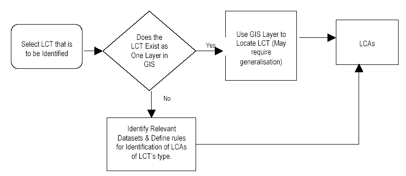
4.6.1 As mentioned above, the methodology assumes that an LCT for an area can be derived either directly from existing digital data or by developing rules for the treatment of a number of datasets to produce the LCT of that area. This treatment is described in Figure 4.2 below.
Figure 4.2 General Treatment for Defining and Mapping LCT/LCAs
4.6.2 It was necessary to determine the appropriate treatment for identifying each LCT: either Data Treatment direct from a single existing dataset, or Rule-based Treatment, by interpolating a number of relevant datasets.
Explanation of Data Treatment Technique
4.6.3 Treatment for LCTs that can be derived directly from a single existing digital dataset is simple as it only requires extraction of appropriate features from the source GIS data file. An example of this would be the Industrial Landscapes LCT. This can be extracted from a land use dataset created under the Land Utilization in Hong Kong Map as a series of polygons and these polygons will be turned directly into LCAs. Some aggregation of small units into larger ones is required as LCAs in general should be 5ha or greater.
Explanation of Rule-based Treatment Technique
4.6.4 The general assumption behind this treatment is, as stated above, that the LCT into which any given area falls is related to a number of physical environmental features of that area. The selection of appropriate boundary defining methods for these LCTs is related to whether the LCT is Non-developed or Developed.
4.6.5 In the case of non-developed LCTs, boundaries can be derived by establishing rules based on environmental characteristics of an area. For example, the 'Peak Landscape’ LCT typically occurs above 300mPD where there is no significant development. By manipulating the supporting topographic data and vegetation data, it is possible to derive LCAs for the majority of non-developed LCTs.
4.6.6 In the case of Developed LCTs, boundaries typically follow man-made features such as street block boundaries. LCAs can then be defined by looking at the combinations of features occurring on each street block. For this technique to work, these features need to exist as mapped datasets. For example, to identify LCAs which fall into the 'High-rise/Medium-Rise Commercial Urban Landscape' LCT, it is necessary to have mapped layers showing:
building locations and height and
the land use zoning of the area (to help define 'commercial').
4.6.7 GIS can then be used to identify street blocks containing a majority of high buildings (say above 40m), in commercially zoned areas. It should be noted that in a small number of cases, key data for distinguishing certain LCT from others (e.g. Rural Township Landscapes) does not currently exist in digital format. Identification of these LCTs was primarily by manual interpretation and expert knowledge
4.6.8 While generally successful, limitations exist with the above-described techniques for automatic identification of LCAs. As mentioned, there was in some cases simply not enough available digital data available to separate all LCTs that may be encountered. The treatment in these cases is either to verify during field survey or manually identify using aerial photographs. In other cases, notably in the case of Rural LCTs, mutually exclusive classification criteria were not always available and the process of defining LCTs requires a sieving and prioritisation process which observes a series of rules. These rules are set out in Appendix 4.
4.7 THE PRELIMINARY LANDSCAPE CHARACTER MAP (PLCM)
Introduction
4.7.1 The Preliminary Landscape Character Map was produced at 1:50,000 scale. It sets out the preliminary pattern of LCTs/LCAs. The methods and basic parameters by which LCTs and LCAs in the PLCM were identified, delimited and named are summarised below.
The Classification Process - Guidelines for the Delineation of LCTs
4.7.2 The general principles and guidelines used in the classification of areas of landscape into different LCTs are presented in Appendix 4. These principles were applied to baseline data using the methods identified above in order to produce the Preliminary Landscape Character Map.
LCA Numbering System
4.7.3 Polygons representing LCAs in the PLCM each have a unique identifier. Originally it was thought that this identifier should help to describe the properties of the LCA (i.e. its LCT and location). However, assigning attribute-based identifiers such as this proved impractical, as many of the LCAs have changed their LCTs during field survey or may change them in the future.
4.7.4 Instead LCAs are identified by reference to a two part identifier, e.g. HKI-302. The first part (i.e. ‘HKI’ in the example) refers to the broad geographic location in which the LCA lies (in this case, HKI representing Hong Kong Island). Hong Kong is divided into eight such areas as follows:
HKI – Hong Kong Island;
OIS – Outlying Islands;
KWL – Kowloon / Tsuen Wan / Shatin;
CWR – Coastal Waters;
SEN – South-east New Territories;
NWN – North-west New Territories;
NEN – North-east New Territories; and
LNT – Lantau.
4.7.5 The second part of the classifier, is a reference number identifying the LCA within the broad geographic area.
Discussion
4.7.6 It is important to appreciate that the PLCM was only a draft first attempt at mapping the landscape of Hong Kong. What became evident to the Study team during this process is that in a Study such as this remote landscape mapping can only be carried out to a certain level of accuracy. Even the most sophisticated GIS or computer software (including those reviewed above) still has difficulty identifying and delimiting, something as apparently simple as, for example, a 'valley'.
4.7.7 The limitations of the accuracy of the PLCM are due to a number of factors:
¨ Data Gaps or Imperfections;
Alternative Data Sources; and
Boundaries Issues.
4.7.8 These issues and the ways in which they affected the PLCM are discussed below.
Data Gaps or Imperfections
4.7.9 In certain cases, data necessary to define an LCT was simply not available in a comprehensive or systematic format to enable that LCT to be plotted on the PLCM. An example of this is the ‘Hui Urban Landscapes’. No authoritative data set exists defining the location and extent of features such as these.
Alternative Data Sources
4.7.10 In certain cases, two or more alternative sources of data were available for a given landscape feature and a choice had to be made as to which data set should be employed. For example, both the SUSDEV21 Habitat Map and the Broad Land Utilization Study contain datasets for woodland. These are however, quite different and based on different criteria. The choice of which data set to use was made generally on the basis of what would most usefully serve the objectives of the Study.
Boundaries Issues
4.7.11 The rule based classification system requires a set of boundaries or areas to be defined to which the rules can be applied. In urban areas, the street block system has been used for this purpose, as streets are normally the best fixed feature at which a change in character can be marked. The use of the street block network can however occasionally result in anomalies. For example, where there is a very large street block which contains two areas of distinctly differing character, only one set of rules will be applied to that block and therefore the whole block will show up as a single LCT. Discrepancies such as this were corrected during field survey.
Methods for Updating and the PLCM
4.7.12 Given the limitations identified above, a number of ways of refining or improving the results of the PLCM were available:
Manual desktop interpretation was one way of ensuring that obvious errors in the PLCM were corrected. This has been used in the case of 'Airport Landscapes’ where the location and extent of the LCT was obvious. In other cases, manual interpretation is far less obvious and would not lead to an acceptable level of accuracy.
Updating during site survey was found to be the best way to update and correct known (and unforeseen) shortcomings in the PLCM. It was also the only way in which the subtleties of landscape character can be adequately captured e.g. the precise difference between ‘Miscellaneous Rural Fringe’ and ‘Miscellaneous Urban Fringe’ Landscapes. Therefore, in most cases, this was the method of updating and correcting the PLCM.
4.8 CONTENT AND STRUCTURE OF THE LANDSCAPE GIS
4.8.1 The purpose of this section of the report is to describe the data sets use from which the PLCM was developed. This was refined as the Study progressed and is presented later in this report.
4.8.2 The procedure used to produce the Preliminary Landscape Character Map involved using existing layers of information representing natural and man-made features to define LCA boundaries. For a number of LCTs, there was not sufficient existing data to delineate LCA boundaries. In these cases, the information below was used to identify District level LCT boundaries. Data layers used for creation of the Preliminary Landscape Character Map and included in the PLCM database are shown in Table 4.3, below. The table makes mention of the source dataset(s) used to construct the layer.
Table 4.3 Data Layers Used in the Creation of the Preliminary Landscape Character Map
Category File Name Description Data Source (or basis of Derivation) Data Type Geomorphology and Topography GEO_GEOLOGY Solid and superficial geology at various scales Derived from GEO geological dataset LINE, POLYGON GEO_BEACH Gazetted and non-gazetted beaches. Derived from AFCD’s Habitat Map POINT, POLYGON GEO_CONTOUR Contour lines with heights. Derived from LIC 1:20,000 topographic data (used in preference to 1:10,000 data for computation time reasons) LINE GEO_SPOTHT Spot heights. Derived from LICs 1:20000 topographic data (used in preference to 1:10,000 data for computation time reasons) POINT GEO_RELIEF Slope tops and bottoms. Derived from LICs 1:1,000 data LINE GEO_DEM Digital Elevation Model Derived from LIC 1:20,000 topographic data (used in preference to 1:10,000 data for computation time reasons) GRID GEO_ORTHO PHOTO Digital orthophoto of Hong Kong LIC Orthophoto IMAGE Hydrological features HYD_RIVER Rivers and streams. Derived from LIC 1:5,000 topographic data used to assist in interpretation. LINE HYD_COAST Coastline Derived from 1:5,000 topographic data LINE HYD_COAST_DIST Distance to Coastline (derived) Derived from 1:5,000 topographic data POLYGON Vegetation Types VEG_GSWB Polygons of Grassland, Shrubland, Woodland and Badlands Derived from PlanD Broad Landuse Map POLYGON Ecological Habitats ECO_INTERTIDAL Polygons representing locations of intertidal LCTs such as mudflat and mangrove. Derived from AFCD habitat map. POLYGON ECO_COASTTYPE Coastline categorised into various natural types. Derived from AFCD Habitat Map LINE, POLYGON Road and Street Patterns ROAD Roads. Derived from LIC 1:1:5,000 data for presentation purpose only. LINE, Railways RAILWAY Railways. Derived from LIC 1:1:5,000 data for presentation purpose only. LINE Building Footprint/ Height BUILDING Buildings with heights where available. Derived from LIC B5,000 and BG1,000 datasets POLYGON Land Use LU_OZPZONE Outline Zoning Plan PlanD OZPs POLYGON LU_LANDUSE Broad Land-use of Hong Kong PlanD Broad Landuse of Hong Kong dataset POLYGON LU_SBVC2001 Street block boundaries From PlanD SBVC2001 data set POLYGON LU_FISHPOND Gei Wei fish ponds from AFCD’s Habitat Map POLYGON LU_VILLAGE Village boundaries from OZP. POLYGON Historical Sites HIST_ARCHSITE Archaeologically significant sites. From LCSD. POINT, LINE, POLYGON HIST_HERITAGESITE Heritage buildings and sites. From LCSD. POINT, POLYGON 4.8.3 The result of the procedure described above is a GIS data layer consisting of polygons. Each of the polygons represents an LCA and is coded with a numeric identifier corresponding to its LCT. Short names and descriptions of these LCTs were stored in what is known as a Look-up table.
4.8.4 In addition to the standard items used to define the polygonal entities in the GIS file, the Attribute Table of the Preliminary Landscape Character Map contained the key items shown in Table 4.4. These key items allowed each polygon representing an LCA to be linked to additional information about that LCA. This extra information was stored in what is known as a Look–up Table.
Table 4.4 Key Items Stored in Preliminary Landscape Character Map Attribute Table
Item Name Description Type Length LCA_ID Unique identifier for each LCA polygon in file Integer 16 LCT_CODE Numeric code identifying the LCA polygon’s LCT. (e.g. Dg(v)6). Links record to look up table Character 16 4.8.5 The Look-up Table contained the items shown in Table 4.5. Its purpose was to store detailed information about the LCTs attributed to each LCA in the PLCM.
Table 4.5 Items Stored in Preliminary Landscape Character Map Look-Up Table
Item Name Description Type Length LCT_CODE Numeric code for each LCT Integer 4 digits LCT_NAME Short name for LCT String 128 digits LCT_DESC Description of LCT String 1000 digits LCT_NOTE Any notes about the LCT String 1000 digits 4.8.6 The Preliminary Landscape Character Map was generated using ESRI’s ArcGIS suite of products and Earth Resource Mappings ERMapper. The format of the Preliminary Landscape Character Map was an ArcGIS Personal Geodatabase. Data stored in this format resided in a Microsoft Jet Database. The text data in the database could be edited using Microsoft Access.
4.8.7 In addition to the Preliminary Landscape Character Map's GIS layers described above, a number of other reference data layers information were included in the database. These datasets and the Government departments they are from are as follows:
1:20,000 scale topographic detail – Lands Department;
Digital Orthophoto at 1:10,000 scale – Lands Department; and
District Boundaries – PlanD.