5.1 THE MAPPING PROCESS - OVERSEAS EXPERIENCE
5.1.1 As there was little local experience of comprehensive landscape mapping in Hong Kong, the Study commenced with a review of different approaches to landscape mapping worldwide, looking at examples from England, Wales, the USA, New Zealand and Indonesia. A number of specific case studies were examined with regard to their assessment methodology, outputs, use of computer technology, public participation and applicability to the Hong Kong situation. The case studies included:
The Countryside Character Initiative, England, United Kingdom;
The LANDMAP Information System, Wales, United Kingdom;
The Cleveland Bioregional Plan, Ohio, USA;
The North Shore City Study, Auckland, New Zealand;
The Waitakere City Study, Auckland, New Zealand; and
The Ujung Kulon National Park Study, Indonesia.
5.1.2 From these case studies, two broadly different approaches to landscape classification and evaluation became evident, namely:
a resource-based approach and
a character-led approach.
5.1.3 The resource-based approach emphasizes individual physical landscape components, which are classified and evaluated individually. By contrast, the character-led approach divides the landscape into different areas of common character and the areas themselves are then evaluated as a whole. Each country studied tended to emphasise different aspects of each approach. In the cases of the USA and Indonesia, they largely adopted the resource-based approach. In the case of England, the character led-approach was used. Wales and New Zealand took something of a hybrid of the two approaches. Table 5.1 summarises the findings of the case studies.
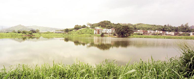 Nam Sang Wai, Yuen Long |
| CASE STUDY | KEY ASPECTS- Approach to Classification / Characterisation |
KEY ASPECTS- Use of Geographical Information System |
KEY ASPECTS- Approach to Evaluation |
KEY ASPECTS- Approach to Public Consultation |
| Countryside Character Initiative, England | + Character-led approach + Comprehensive national approach, using LCAs and LCTs - Scale of LCTs too large for Hong Kong |
+ GIS used to define character
areas via computer software + GIS used as information storage and management tool + Data included both 'pattern' data and 'feature' data in both graphic and textual form + GIS used as a tool to analyse forces driving landscape change over time |
- Rather complex environmental capital approach |
- No significant public consultation |
| LANDMAP Information System, Wales |
- Division of classification
responsibility by Aspect area - Classification system rather than 'characterisation' system |
+ GIS used as information
storage and management tool - GIS not (explicitly) used as a tool for classification / characterisation |
+ Separation of evaluation of
Aspect areas from evaluation of character + Evaluation of Visual and Sensory aspect in terms of value, condition and trend + Transparent use of structured evaluation proformas + Separate assessment of sensitivity |
+ Formal public consultation - Public consultation only on landscape character areas (not Aspect areas) |
| Cleveland Bioregional Plan, USA | - Classification /characterisation not part of study methodology | + GIS used largely as a public communication tool | - No formalised evaluation method | + Dissemination of
information via the internet + Use of public fora |
| North Shore City Study, Auckland, New Zealand | + Character-led approach - Only one tier of characterisation + Reasonably small scale of LCTs |
+ GIS used as information storage and management tool | + Separation of evaluation of
landscape character and landscape features + Transparent use of structured evaluation proformas + Distinction between landscape value, sensitivity, vulnerability, key attributes |
+ Public review of study scope, objectives, assessment criteria. |
| Waitakere City Study, Auckland, New Zealand | + Character-led approach + 2 tiers of characterisation + Reasonably small scale of LCTs |
+ GIS used as information storage and management tool | + Transparent use of
structured evaluation proformas - Concentration on visual values |
+ Public review of study scope, objectives, assessment criteria and study findings. |
| Ujung Kulon National Park, Indonesia | - Integration of classification
and evaluation - No representation of human or cultural or visual parameters |
+ GIS used to manipulate parametric data and then to define landscape units via computer software | - Integration of
classification and evaluation - Scoring of value/sensitivity now somewhat discredited + Use of sensitivity as a criterion of value |
- No evidence of public consultation |
| NOTES | ||
| LCT - LCA - Aspect Area - |
Landscape Character Type Landscape Character Area A hierarchical classification system for information on earth science, biodiversity, visual and sensory, history and archaeology and culture |
|
| + - |
Approach potentially appropriate or useful to the current Study Approach not appropriate or useful to the current Study |
5.1.4
The approach adopted for this Study was largely a hybrid approach, using landscape character as a basis for landscape classification. This analysis of
character was then used to identify key landscape resources to be used in sustainability assessment. A simplified study methodology is presented in
Figure 5.1.
Figure 5.1 Study Process Diagram
STAGE 1
Review Local and Overseas Experience and define Study Methodology
STAGE 2
Establish Classification System and Evaluative Criteria
STAGE 3
Carry out Desktop Research and Field Survey to collect Baseline Information
STAGE 4
Analyse Data obtained in Stage 3 and produce the Landscape Character Map,
GIS Database and recommend a Landscape Indicator
5.2 MAPPING THE LANDSCAPE – THE LANDCAPE CHARACTER APPROACH
5.2.1 Using the selected approach (termed the 'Landscape Character Approach'), Hong Kong was divided into different areas (termed 'Landscape Character Areas'(LCAs)) based on differences in the character of the landscape.
5.2.2 In general, landscape is given its character by, a number of natural and man-made features (see Table 5.2).
| Natural Features | Human Features |
| Solid Geology Drift Geology (i.e. soils) Topography Natural Hydrological Features (e.g. streams, rivers, lakes) Vegetation Coastal Water (i.e. sea) |
Built-form (settlements) Land Use Transportation Features Features of Heritage / Cultural value Artificial Hydrological Features (e.g. fish ponds, nullahs, reservoirs) |
5.2.3 Based on these features, landscape can be sorted into different types or units, each with a distinct, consistent and recognisable character. Two types of landscape unit are identified i.e. Landscape Character Types (LCTs) and Landscape Character Areas (LCAs):
LCTs are generic types of landscape which have a broadly similar pattern of landform, vegetation, land use and settlement pattern etc. in every area where they occur. They are given generic names describing their component parts, such as 'Uplands and Hillsides' Landscapes' or 'Peaks Landscapes'.
LCAs are specific geographic examples of LCTs, which reflect most of the general characteristics of the LCTs, but at the same time have their own unique identity. They are given specific names which reflect their particular locations, such as "Tai Mo Shan Peak". Therefore any LCA can be seen as an example of a wider generic LCT.
5.2.4 LCTs and LCAs can be further broken down into smaller sub-types or sub-areas at different level, i.e. from broad territorial level down to detailed local level. For this Study, landscapes were first divided into six broad LCTs at sub-regional level. They are:
Upland Countryside Landscape;
Lowland Countryside Landscape;
Rural Fringe Landscape;
Urban Landscape;
Urban Fringe Landscape; and
Coastal Waters Landscape.
5.2.5 These broad LCTs were further sub-divided into 41 district-level LCTs in order to produce a classification of Hong Kong's landscape. The full list of LCTs is provided in Appendix 1.
5.2.6 Applying the district-level LCT classification to the landscape of Hong Kong, the Study has identified 943 LCAs across the territory. A Landscape Character Map showing the distribution of district-Level LCTs is shown in Figure A1 of Appendix 1.
5.3 ASSESSING LANDSCAPE – CHARACTER, CONDITION, SENSITIVITY TO CHANGE AND VALUE
5.3.1 The ways in which landscape may be assessed is a topic covered by an extensive body of research literature. A review of case studies concluded that for this Study, landscape should be assessed against four key variables:
Landscape Character;
Landscape Condition;
Landscape Sensitivity to Change; and
Landscape Value.
5.3.2 Landscape Character is the aggregate impression created by the most significant landscape features within each LCA when viewed together as a whole. This is recorded as a written description and in photographs.
5.3.3 Landscape Condition is the integrity of the pattern of positive landscape features which make up the character of the landscape. The landscape condition of each LCA is graded 'Good', 'Moderate' or 'Poor' and a corresponding landscape management strategy (conservation/ enhancement / reconstruction) is recommended.
5.3.4 Landscape Sensitivity is the ability of a landscape to accommodate change without prejudice to its existing landscape character. For each LCA, landscape sensitivity is assessed as 'More Sensitive' or 'Less Sensitive' to a given list of potential development types.
5.3.5 Landscape Value is the importance we attach to a landscape. Landscape may gain value or be considered important because of its scenic quality, its heritage or nature conservation interests or its distinct sense of place. Specifically, landscape value is assessed by taking into account visual coherence, complexity, rarity, relief and condition, key heritage/natural features and visual attractors / detractors. Landscape value may be ranked as 'High', 'High(Qualified)', 'Moderate' or 'Low'.
5.3.6 Details of the basis of the assessment of landscape value and value rankings are provided in Appendix 2. The following key issues were considered relevant to the evaluation of landscape value:
Intrinsic and Extrinsic Values in Landscape
5.3.7 It is important to draw a distinction between a landscape's intrinsic value and its extrinsic value. Intrinsic value is the value of a landscape 'as a landscape' or 'relative to other landscapes'. Extrinsic value is the value of a landscape relative to other resources or assets, such as 'economic growth', 'job creation' or 'housing provision'. This Study addresses only intrinsic landscape value.
Visual and Non-Visual Values in Landscape
5.3.8 Not all landscape values are necessarily visual. Any landscape is the product of physical, historical and biological processes and the landscape itself may gain value by virtue of its special historic associations (e.g. historic structures) or biological associations (e.g. rare natural habitats).
Subjectivity, Objectivity and Consensual Landscape Values
5.3.9 The Study recognises that the appraisal of landscape value contains a significant subjective element. However, it is important to note that these subjective judgements are made on a rational and coherent basis. During the process of evaluation, what is most important is that criteria should be open and transparent and that judgments are made rationally. In addition, it is possible to identify considerable public and professional consensus with regard to subjective landscape values (demonstrated e.g. by recognised convention and the views of expert writers).
5.4 SURVEYING THE LANDSCAPE - A STRUCTURED AND CONSISTENT APPROACH
5.4.1 An extensive field survey of the whole of Hong Kong was carried out to identify and record in detail the characteristics and features of each LCA. The field surveys were undertaken by teams of Landscape Architects, trained in the analysis and evaluation of landscape.
 Field Survey Photography |
5.4.2 Each of the 943 LCAs in Hong Kong was surveyed on foot, by car, by boat or, in the case of remote and inaccessible locations, by helicopter.
5.4.3 Prior to the main survey, a pilot survey on Lantau Island was carried out to train the survey team members and to test the field survey methodology, transport and logistics arrangements and survey instruments.
5.4.4 At each LCA, a record photograph was taken and the character of the landscape and its key features was marked down. Each area of landscape was assessed against each of the variables noted above, using a series of pre-determined criteria.
5.4.5 In carrying out the assessment, it was recognised that there is a certain element of subjectivity involved. However, this does not mean that such judgements were in any way arbitrary or unreasoned. In order to minimise subjectivity, all evaluations were carried out:
Professionally: each survey team consisted of two trained professional Landscape Architects, allowing members to discuss findings with each other and cross-check assessments.
Transparently: the survey was carried out using a survey record sheet containing all assessment criteria. A copy of the survey record sheet is shown at Appendix 3.
Consistently: the use of a standardised survey record sheet ensured that the same assessment criteria were applied in the same way across a range of circumstances during the surveys. Clear guidelines to assist the survey teams in making assessments were also provided.
Rationally: the survey record sheet consisted of clearly defined evaluation criteria and, where appropriate, reasons for the evaluation were recorded.
5.5 INFORMATION TECHNOLOGY IN THE MAPPING PROCESS
5.5.1 During the study process, a Geographical Information System (GIS) was used extensively at various stages in the process.
Information Technology During the Landscape Classification Process
5.5.2 A number of the case studies used computer based techniques - in particular, GIS - to classify landscapes and store data. The following provides an account of the application of such information technology in this Study.
5.5.3 When the study team began the mapping process, GIS was used to store data on landscape features for preparation of an initial classification of landscapes into predetermined types. This was achieved by developing a series of rules based on the occurrence of specific landscape features for each LCT. This approach assumes that each LCT possesses an unique combination of landscape features which make it distinct from any other LCT. By programming the rules used into the GIS, it was able to produce a preliminary Landscape Character Map of all the LCAs in Hong Kong.
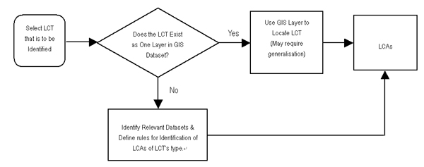
5.5.4 This 'rule-based' methodology assumes that a LCT for an area i.e. a LCA can be derived either directly from existing digital data or alternatively, by developing rules for the treatment of a number of datasets to identify a particular LCT. The alternative approaches are described in Figure 5.2.
Figure 5.2 General Treatment for Defining and Mapping LCT/ LCAs
5.5.5 In the Study, digital data on landscape features was compiled as data layers in Arcview, a common GIS platform used by the Hong Kong SAR Government. This landscape data included data on topography and altitude, soil type, hydrological features, vegetation type, ecological habitat, roads and streets, railways, building footprint and height, land use and historical sites, which were found for the most part in the Land Information System (LIS) of Lands Department and the territorial habitat map prepared under the Study on Sustainable Development for the 21st Century (SUSDEV21).
5.5.6 In the case of Urban, Urban Fringe and Rural Fringe LCTs, classification is by reference principally to land use and relies mainly on mutually exclusive criteria which are relatively well-defined. For example, Hong Kong International Airport at Chek Lap Kok can only be classified as 'Airport Landscape' and a golf course only a 'Golf Course Landscape'. Other developed LCTs can be defined by a combination of mutually exclusive attributes such as height of buildings, type of land use and density of building footprints. In the case of Upland and Lowland Countryside LCTs, rules were defined mainly by reference to topography and land use.
5.5.7 The preliminary Landscape Character Map was a first attempt at classifying and mapping the landscape of Hong Kong. It became evident to the study team during this process, that remote, 'automated' landscape mapping can only be carried out to a certain level of accuracy. The limitations on the accuracy of the preliminary Landscape Character Map were due to a number of factors, primarily data gaps or imperfections and also problems in finding coherent features on the ground to serve as LCA boundaries.
5.5.8 Given the limitations identified above, the preliminary Landscape Character Map was subsequently refined manually at desktop and updated during field survey.
The Landscape Character Map and GIS Database
5.5.9 The findings of the Study (including the Final Landscape Character Map and digital database of information on every landscape in Hong Kong) have been collated onto a GIS. Polygons representing LCA boundaries in the Landscape Character Map have a unique identification number which is linked to their attributes stored in the GIS database. The Map can be viewed and interrogated interactively to explore different landscapes and to view their boundaries, descriptions, attributes and record photographs. The organization of datasets in the GIS database is shown in Table 5.3 below:
| Folder Name | Sub Folder Name | Data Description | Data Format |
| LCM_GIS | |||
| Landscape Classification | Natural & Human Features layers | Personal GDB | |
| Landscape Evaluation | Landscape Features layers |
Personal GDB | |
| Landscape Character Area | Final re-classified LCA layer | Personal GDB | |
| Photos | LCA Field survey photos | MOV, JPG | |
| LCA Description | LCA description files | ||
| Mxd | ArcGIS project document | ArcMap MXD |
Note : GDB – Geo Database
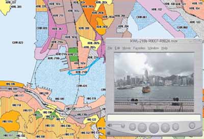
5.5.10 The GIS database contains all the data on landscape features which were used or generated during the Study. In addition, users can browse various spatial data layers on the map window, perform enquiries and conduct sophisticated spatial analysis. Hyperlinks have been created for each LCA polygon. Users can click on a particular LCA and the corresponding LCA's description report file and photographs will be opened, as shown in Figure 5.3 below.
Figure 5.3 Typical GIS Database Screen
5.6 STAKEHOLDER ENGAGEMENT AND PUBLIC CONSENSUS
5.6.1 The Study is highly technical and specialised in nature. To ensure openness and transparency, opportunities have been taken to engage the public and stakeholders throughout the study process and to obtain their feedback on the Study. This engagement process included the following activities:
The Town Planning Board, Planning Sub-Committee of the Land and Building Advisory Committee and the Hong Kong Institute of Landscape Architects (HKILA) were consulted on the study scope before the Study commenced.
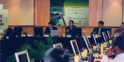
A Value Management Workshop for stakeholders, including international experts on the field, representatives from Government departments, concern groups, professional institutes such as the Hong Kong Institute of Planners (HKIP) and HKILA and academics, was held in December 2001 to seek initial ideas on the study methodology.
A public consultation on the initial findings of the Study i.e. landscape classification criteria and evaluation framework, was carried out between July and September 2002. There were altogether eight presentations and briefings to various statutory and advisory bodies and professional institutions. In addition, a Focus Group Workshop was held in July 2002 and attended by about 30 participants.
Another workshop for stakeholders (Hong Kong Institution of Engineers, HKIP, Green Lantau Association, academics from universities, Real Estate Developers Association, etc.) was held in September 2003 to share views on the findings of the pilot field survey of Lantau Island with a view to improving the survey process. There were also further exchanges of views through correspondence between these parties.
All the technical reports prepared in the Study were provided to the HKILA, HKIP, and academics in universities to seek their expert responses.
 Focus Group Workshop, July 2002 |
5.6.2 Overall, stakeholders and the public were generally supportive of the Study. Their positive response showed that there was an expectation that the Study would provide a timely and useful contribution to the appreciation and protection of Hong Kong's landscape resources.
5.6.3 In particular, there was much useful feedback from the public consultation exercise held in late 2002 which had a bearing on the approach to the Study. Some points worthy of specific mentioned are as follows:
There were suggestions that the Study should include a regional context and that it should extend to cover Shenzhen. The study team considered that the main objective of the Study was to obtain landscape baseline information of Hong Kong and there were deemed to be practical difficulties in conducting field survey across the boundary. Nevertheless, the effects of the visual setting of Shenzhen on the landscape of northern parts of the New Territories have been examined in the Study.
Comments were also made on the classification and the scale of LCTs, in particular that areas such as street markets, public squares or streams/waterfalls had not been captured as individual LCAs. The Study team was of the view that some of the features mentioned were in fact, too small to be considered landscapes in their own right. However, under the study approach, all such features could potentially be considered as significant landscape features of wider landscapes and were addressed in this way during the Study.
There were concerns over the extent to which the assessment of landscape involved elements of subjectivity. The Study team considered, as explained in Section 5.4 of this report, that the key to the Study's evaluation process was that value judgements were made by trained professionals during field surveys, on a rational basis (i.e. on reasoned grounds); transparently (i.e. using clearly defined criteria with reasons clearly recorded) and consistently (i.e. applying the same criteria in the same way across different locations). The Study also reviewed and took into account relevant published literature and the results of available opinion polls on landscape issues.
Many consultees suggested that significant natural or cultural landscapes should be identified for protection. The study team pointed out that recommending designation of specific landscapes for protection or enhancement was not part of the Study's objectives. The Study has, however, yielded sufficient information to be used as the basis for designation of special landscape areas, if it is considered desirable after completion of the Study.
A range of landscape types or attractive / unattractive landscape features was provided by consultees. Specific places and landscapes that were thought to be of high or low landscape value were also suggested. All these suggestions were subsequently taken into account in the Study during landscape evaluation.