
6.1 INTRODUCTION
6.1.1 There are many possible uses of the Landscape Character Map and the database. During the course of the Study, interim findings have been employed for a number of planning purposes. The following suggests some potential uses of the Study findings.
6.2 SUSTAINABILITY INDICATOR FOR LANDSCAPE
6.2.1 One of the requirements of the Study is to recommend potential Landscape Indicator(s) for incorporation into Hong Kong Government's sustainability assessment tool – CASET, which is used to predict the sustainability of major development proposals.
6.2.2 Two landscape indicators have been investigated and evaluated. These are:
Indicator based on 'Area of High Landscape Value'; and
Indicator based on 'Significant Landscape Features'.
Value-based Indicator
6.2.3 High Landscape Value Areas (HLVAs) - LCAs with high landscape value are identified in the Study, as mentioned in Chapter 3. This indicator would operate by measuring the net loss/gain to the area of LCAs with 'High' landscape value.
6.2.4 The proposed measurement of landscape change would be 'Percentage change to area of LCAs with High Landscape Value'.
Feature-based Indicator
6.2.5 Significant Landscape Features (SLFs) are proposed to measure the positive aspects of landscape character. There are two types of SLF:
Area-based SLFs: these generally include extensive natural landscape features, such as woodland, streams, fishponds etc., which are not edifices or constructions; and
Point-based SLFs: these include landscape features of limited extent, such as buildings, edifices, structures or built landscape features (e.g. monuments, bridges) landmark geological or physiographic features and hydrological features with limited horizontal extent such as waterfalls, etc.
6.2.6 This indicator would operate by measuring the net loss/gain in the areas or number of SLFs of each type. The proposed measurement of landscape change would be:
'Percentage change to area of Area-based SLFs'; and
'Percentage change to number of Point-based SLFs'.
6.2.7 In addition to SLFs, it is recommended that an advisory mechanism be incorporated into CASET whereby potential impacts on LCAs with high landscape value would be flagged up as an alert to CASET users.
6.2.8 A full list of the two types of SLFs is provided in a table in Appendix 4. Baseline conditions of SLFs would be derived from information collected during the Study.
6.2.9 For consideration of the Hong Kong Government, a comparison of the two potential indicators based on the performance criteria laid down in SUSDEV21 was carried out and is summarised in Table 6.1 below.
| Criteria | HLVA Indicator | SLF Indicator(s) |
| Simple, Easily Understood and Robust | Simple and easily understood. However, the meaning of "landscape value" is more complex than its intuitive meaning and is in fact a more complex concept and not as robust as it might at first appear. | More sophisticated and requiring greater data collection and analysis. Manipulation of the datasets from the Study is required to derive the baseline condition of SLFs. However, significant features such as woodland, beach, wetland, natural streams and parks etc. are generally accepted as positive landscape elements and treasured by the public. |
| Policy Relevant / Multi-directional | Limited relevance. The indicator measures change only against LCAs with existing 'High' landscape value or those which are improved to that value. Policy efforts to improve landscapes over limited areas (such afforestation of upland badlands or creation of parks, may not be reflected in the Indicator) if they do not change the value of the LCA as a whole. | Relevant. As the
Indicator is comprehensive and measures change in all landscapes, irrespective of existing value, policy efforts such as afforestation programmes and creation of urban parks would be reflected by a direct positive measurement in the indicator. |
| Sensitivity to Change | Limited sensitivity. The Indicator is problematic in that it rests on a false assumption that the area of new development within a given LCA can be equated with an equivalent quantum reduction in landscape value. In addition, the Indicator incorrectly assumes that all development has an intrinsically negative effect on landscape value, which is not the case. | Sensitive. Any development initiatives leading to reduction or increase of the SLFs will be directly recorded by a change in the SLF indicator. |
| Measurable | Partially measurable. Though the area of HLVA affected by change can be measured, true qualitative change may not be captured (as mentioned in (3) above). Positive change (i.e. improvement in the landscape) cannot be readily captured. | Measurable. Measuring the change of SLF indicator should be straightforward and a true reflection of change in the landscape. Positive change to the landscape can be captured. |
| Capable of
Showing Trend Over Time |
Partially effective in showing trends. Negative trends can be captured, but not positive ones. For example, it can be reasonably speculated, that completion of the Disneyland project at Penny's Bay will enhance the landscape value of the LCA over its value as a construction site. But it is not clear if such enhancement would upgrade the LCA to 'High' landscape value until a full assessment is carried out after completion of the project. Remote prediction of the future trends with regard to landscape value is difficult and uncertain. | Effective in remotely showing both negative and positive trends in a very simple way. For example, landscape improvements such as those ongoing at Penny's Bay are likely to be easily recorded and updated to the Indicator database. |
| Scientifically or Analytically Valid | Unclear. Although assessment of landscape value in the Study is based on a set of clear and objective criteria, takes account of established public consensus and is carried out by professionals, the assessment process contains significant subjective components. | Reasonably valid. Although the list of SLFs may not be exhaustive and may be subject to change, adding or deleting SLFs from the list would not affect the logic and validity of the approach. Moreover, a feature-based landscape indicator is also the most commonly employed in other European societies. |
| Capable of Updating at Regular Interval | Capable. Landscape value of LCA can be updated regularly by conducting landscape survey, though this will require a specialist field survey to be carried out. | Capable. Baseline conditions of SLFs can be reviewed regularly when the database is updated. Data can also be updated remotely using Remote Sensing Technologies. |
6.3 LANDSCAPE IMPACT ASSESSMENT OF STRATEGIC DEVELOPMENT
PROJECTS
6.3.1 The Landscape Character Map can be used as baseline information in carrying out Landscape and Visual Impact Assessments (LVIAs), which are a component of the Environmental Impact Assessment (EIA) process.
6.3.2 In fact, consultants carrying out the preliminary environmental review for the Hong Kong – Pearl River West Link for Highways Department in November 2002, have specifically made reference to the initial findings of the Study to prepare their landscape and visual impact assessment of landfall options.
6.4 USE IN PREPARATION OF TOWN PLANS
6.4.1 The Landscape Character Map can be made available for use by Planning Department as background information in preparing Outline Zoning Plans and other planning studies, ensuring landscape issues are adequately represented in the planning process.
6.5 OTHER POTENTIAL USES
6.5.1 Various Government Departments such as Leisure and Cultural Services Department, Agriculture, Fisheries and Conservation Department, Highways Department and others are tasked with maintaining various components of the public landscape in urban and rural areas. The Landscape Character Map will also be of value to them as background information when determining maintenance strategies and actions.
 |
|
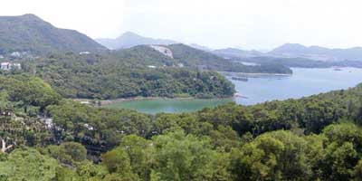
Tai Mong Tsai , Sai Kung |
6.6 LIMITATIONS OF THE LANDSCAPE CHARACTER MAP
The Landscape Character Map and Future Development
6.6.1 The Study is a baseline survey of existing landscape condition and value. During the field survey, the study team took into account only the existing situation at each LCA, without considering the effects of any planned or committed developments therein (simply because it is not possible to accurately assess a proposal that has not yet been implemented). For example, Penny's Bay attained a low landscape value because the area was then under construction. However, the landscape will be drastically improved upon completion of the Disneyland project. A remark has been included in the database to highlight any ongoing major developments within LCAs which will significantly affect their character. Users of the Landscape Character Map and GIS database should be aware of such facts when interpreting the study findings.
Landscape Assessment and Subjectivity
6.6.2 As has been mentioned earlier, landscape evaluation and assessment contain a significant subjective component. To reduce subjectivity and ensure general public acceptance of the findings, opportunities have been taken to engage stakeholders early in the Study to determine the assessment methodology (see para. 5.6.1 above). An impartial judgment on the value of each LCA was also achieved during the field surveys by employing professional Landscape Architects to carry out the assessment. In addition, assessments were based on a set of predefined criteria and justifications have been clearly recorded in the field data record sheet which can be re-examined if required. Finally, the study team has extensively reviewed local literature and relevant research to provide support for their assessments.
LCA Boundaries
6.6.3 It is well recognised that landscape is a continuum and that character does not in general change abruptly. However, for the sake of certainty, the boundaries of LCAs were generally mapped following definable features on the ground, such as roads, buildings, coastal features, fences or drainage channels etc. In applying the findings of the Study at a detailed local level, users are advised to examine the LCA boundaries and review and refine them as necessary to ensure that the study findings would be meaningful in a local context.