3.1 INTRODUCTION
3.1.1 This section of the report presents both the Draft Landscape Character Map and provides an overview of the GIS Database, both key outputs of this phase of the Study. The finalised GIS database produced as part of TR5 will be shown as part of the Final Report for the Study.
3.2 DRAFT LANDSCAPE CHARACTER MAP (LCM)
3.2.1 The Study Brief states at Para 6.10(5) that the Consultants shall:
3.2.2 "Prepare a draft landscape character map…in GIS format compatible with that used in the sustainability evaluation tool developed under the SUSDEV21 Study...GIS map processing software...shall be used to prepare the final interpretation and presentation of the map".
3.2.3 The Draft LCM, containing 943 LCAs is presented in GIS format. For ease of reference, a hard copy of the Draft LCM for the whole of the HKSAR is contained in Appendix 2.
3.3 GIS DATABASE
INTRODUCTION
3.3.1 The Study Brief states at Para 6.10 (6):
3.3.2 "A stand-alone GIS shall be developed and utilized in dealing with the different layers of information to be mapped, calculating the extent, assessing their inter-relationships and linking each LCT and LCA with:
Their associated database and relevant attribute tables;
Their photographic records taken at vantage points;
A system for data storage and retrieval of written description and illustration.
3.3.3 The number of information layers to be included in the GIS and how the database and photographic records should be organized shall be subject to the agreement of the DR. The database and photographic records should be in a format that can be easily updated and refined when more information is available."
3.3.4 The GIS database developed as part of the Study contains layers of spatial data used during the production of the Landscape Character Map, as well as final LCA polygons. In addition, relevant base map layers are also included in the GIS database for reference. For each LCA, corresponding site survey photographs and survey information is also attached.
3.3.5 The purpose of this section is to describe the structure of the GIS database and provide basic instructions as to its use.
STRUCTURE OF GIS DATABASE
3.3.6 The organization of datasets in the proposed GIS database is shown below:
Table 3.1 Organisation of GIS Database
Folder Name Sub Folder Name Data Description LCM_GIS Landscape Classification Natural & Human Features layers Personal GDB Landscape Evaluation Landscape Features layers Personal GDB Landscape Character Area Final re-classified LCA layer Personal GDB Photos LCA Field survey photos MOV, JPG LCA Description LCA description files Mxd ArcGIS project document ArcMap MXD 3.3.7 An ArcMap project document file (LCM_GIS.mxd) is stored in the “Mxd” folder. This project file provides a user-friendly interface for data integration for all spatial data stored in the GIS database. Users can browse various spatial data layers on the map window, perform queries and conduct sophisticated spatial analysis.
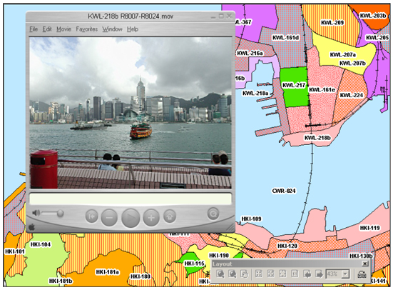
3.3.8 In addition, hyperlinks have been created for each LCA polygons. Users can click on a particular LCA of their interest and the corresponding LCA’s field survey photo or LCA description report file will be opened for detail investigation. Figures 3.1 & 3.2 show captured images, which illustrate this function.
'Landscape Classification' Folder
3.3.9 The 'Landscape Classification' folder contains various spatial data layers stored in ArcGIS personal geodatabase (GDB) format. Data is physically stored in a Microsoft Access MDB files named: "Landscape_Class.mdb". The geodatabase is sub-divided into several feature datasets including both human and natural categories, such as: Ecological Habitats, Geomorphology and Topography, Hydrology and Vegetations categories, Building footprint, Historical Sites, Land Use, Railways and Road Pattern categories. The detailed data layers are listed in Table 3.2.
3.3.10 All natural and human features map data layers were used during the production of the Preliminary Landscape Character Map as well as final stage Landscape Classification and Evaluation.
3.3.11 In addition, a digital elevation model (DEM) is also included in the 'Landscape Classification' folder. The file is in ESRI raster GRID format with a resolution of 50m, covering the whole territory. This dataset is derived from LIC 1:20,000 topographic data.
Table 3.2: Data Layers Used in the Creation of the Preliminary Landscape Character Map
Feature Dataset Feature Class Description Data Source (or basis of Derivation) Geometry Type Building Footprint BUILDING_5K_ANNOCHI Buildings Chinese annotation LIC B5000 datasets ANNO BUILDING_5K_ANNOENG Buildings English annotation LIC B5000 datasets ANNO BUILDING_5K_ANNOHSNO Building House Number LIC B5000 datasets ANNO BUILDING_5K_POLYGON Buildings with types where available. LIC B5000 datasets ANNO Ecological Habitats ECO_COASTTYPE Coastline categorised into various natural types. Derived from AFCD Habitat Map LINE ECO_INTERTIDAL Polygons representing locations of inter-tidal LCTs such as mudflat and mangrove. Derived from AFCD Habitat Map POLYGON Geomorphology and Topography GEO_BEACH Gazetted and non-gazetted beaches. Derived from AFCD’s Habitat Map POLYGON GEO_BEACH_GAZETTED Gazetted beaches Derived from AFCD’s Habitat Map POINT GEO_BOULDER Areas of boulder material from API Derived from GEO boulder API dataset POLYGON GEO_CONTOUR_20K_ANNO Annotation of B20000 contours Derived from LIC 1:20,000 topographic data ANNO GEO_CONTOUR_20K_ARC Contour lines with heights. Derived from LIC 1:20,000 topographic data LINE GEO_GEOLOGY_SOLID Solid geology at various scales Derived from GEO geological dataset POLYGON GEO_GEOLOGY_SUPERFICIAL Superficial geology at various scales Derived from GEO geological dataset POLYGON GEO_RELIEF_1K_ANNO Annotation of B1000 Relief features Derived from LIC 1:1000 topographic data ANNO GEO_RELIEF_1K_ARC Slope tops and bottoms. Derived from LICs 1:1,000 topographic data LINE GEO_SPOTHT_20K_ANNO Annotation of B20000 Spot height features Derived from LIC 1:20,000 topographic data ANNO GEO_SPOTHT_20K_POINT Spot heights. Derived from LICs 1:20000 topographic data POINT Historical Sites HIST_ARCHSITE Archaeologically significant sites. From LCSD. POLYGON HIST_HERITAGESITE Heritage buildings and sites. From LCSD. POINT Hydrological features HYD_COAST Coastline Derived from 1:5,000 topographic data LINE HYD_RIVER_5K_ANNOCHI Chinese Annotation of B5000 hydrology features Derived from 1:5,000 topographic data ANNO HYD_RIVER_5K_ANNOENG English Annotation of B5000 hydrology features Derived from 1:5,000 topographic data ANNO HYD_RIVER_5K_ARC Rivers and streams. Derived from LIC 1:5,000 topographic data used to assist in interpretation. LINE Land Use LU_FISHPOND Gei Wei fish ponds From AFCD’s Habitat Map POLYGON LU_LANDUSE Broad Land-use of Hong Kong PlanD Broad Landuse of Hong Kong dataset POLYGON LU_OZPZONE Outline Zoning Plan PlanD OZPs POLYGON LU_SBVC2001 Street block boundaries From PlanD SBVC2001 data set POLYGON LU_VILLAGE Rural villages Village boundaries from OZP. POLYGON Railways RAILWAY_5K_ANNOCHI Chinese Annotation of B5000 Railway features Derived from LIC 1:5,000 data ANNO RAILWAY_5K_ANNOENG English Annotation of B5000 Railway features Derived from LIC 1:5,000 data ANNO RAILWAY_5K_ARC Railways. for presentation purpose only. LINE Road and Street Patterns ROAD_5K_ANNOCHI Chinese Annotation of B5000 Road features Derived from LIC 1:5,000 data ANNO ROAD_5K_ANNOENG English Annotation of B5000 Road features Derived from LIC 1:5,000 data ANNO ROAD_5K_ARC Roads Derived from LIC 1:1:5,000 data for presentation purpose only. LINE Vegetation Types VEG_GSWB Polygons of Grassland, Shrubland, Woodland and Badlands Derived from PlanD Broad Landuse Map POLYGON Landscape Classification' Folder
3.3.12 The 'Landscape Evaluation' folder contains two sets of landscape feature data layers. These data layers contained value information derived from authoritative Chinese and English literature sources. One data set is for Chinese references and the other is for English ones. The purpose of such data layers is to record features and areas significant in defining landscape value. This information falls either into the class of a discrete feature of landscape value significance or a more generalised area of landscape value significance. The detailed data layers are listed in Table 3.3 and 3.4
Table 3.3: Map Layers Used for Landscape Evaluation (Chinese Version)
Feature Dataset Feature Class Description Geometry Type Sense of Place PLACE_LINE Streams, Footpaths, Ridgelines, Coastline, Escarpment, Dam, Street, Bridge LINE PLACE_POINT Peak, Waterfalls, Geomorphologic features including Rocks, Arches & Blow Holes, Crags, Cliffs, Building POINT PLACE_POLYGON Beach, Rocky Foreshore, Mud flat, Small Island, Bay-inlet, Reservoirs, Villages, Valley, Badland, Landform, Ridge, Upland Plateau, Country Park, Public Open Space, Marine Basin, Building-extensive POLYGON Visual Attractor POSVAL_LINE Streams, Footpaths, Ridgelines, Coastline, Escarpment, Landmark Structures LINE POSVAL_POINT Peak, Waterfalls, Geomorphologic features including Rocks, Arches & Blow Holes, Crags, Cliffs, Landmark Buildings (localised) POINT POSVAL_POLYGON Beach, Rocky Foreshore, Mud flat, Small Island, Bay-inlet, Reservoirs, Villages, Valley, Badland, Landform, Ridge, Upland Plateau, Country Park, Public Open Space, Marine Basin, Landmark Structures (extensive) POLYGON Others HIST_BUILDING Historic buildings POINT SSSI Site of Special Scientific Interest POLYGON Table 3.4: Map Layers Used for Landscape Evaluation (English Version)
Feature Dataset Feature Class Description Geometry Type Sense of Place PLACE_LINE Streams, Footpaths, Ridgelines, Coastline, Escarpment, Dam, Street, Bridge LINE PLACE_POINT Peak, Waterfalls, Geomorphologic features including Rocks, Arches & Blow Holes, Crags, Cliffs, Building POINT PLACE_POLYGON Beach, Rocky Foreshore, Mud flat, Small Island, Bay-inlet, Reservoirs, Villages, Valley, Badland, Landform, Ridge, Upland Plateau, Country Park, Public Open Space, Marine Basin, Building-extensive POLYGON Visual Attractor POSVAL_LINE Streams, Footpaths, Ridgelines, Coastline, Escarpment, Landmark Structures LINE POSVAL_POINT Peak, Waterfalls, Geomorphologic features including Rocks, Arches & Blow Holes, Crags, Cliffs, Landmark Buildings (localised) POINT POSVAL_POLYGON Beach, Rocky Foreshore, Mud flat, Small Island, Bay-inlet, Reservoirs, Villages, Valley, Badland, Landform, Ridge, Upland Plateau, Country Park, Public Open Space, Marine Basin, Landmark Structures (extensive) POLYGON Others HIST_BUILDING Historic buildings POINT SSSI Site of Special Scientific Interest POLYGON 'Landscape Classification' Folder
3.3.13 This folder contains a single GIS data layer physically stored in the personal Geodatabase (MDB file). The map layer contains 943 LCA polygons, each of them representing a particular LCA. Each polygon is coded with a numeric identifier corresponding to its LCT. Critical attribute information about LCAs is stored in the layer’s attribute table. Such attributes can assist the user in quick LCA identification. Key attribute items are listed in Table 3.5.
Table 3.5: Key Items Stored in Landscape Character Area Polygon Layer Attribute Table
Item Name Description Data Type Length OBJECTID_1 I nternal unique object identifier code for polygon in file Integer - Shape Internal geometry linkage Geometry - RD_LCA Unique identifier for each Landscape Character Area (LCA) polygon Text 50 RD_LCA_NAM Full name of each LCA Text 254 RD_LCT Classified Landscape Character Type code for LCA polygon Text 50 LCT Full name of each Landscape Character Type (LCT) V_O_LCA Overall Landscape Value for each LCA Text 128 V_SP_CONDT Overall Landscape Condition for each LCA Text 128 V_VT Significant Change Ongoing Value Text 12 SHAPE_LENGTH Internal perimeter for each LCA polygon Double - SHAPE_AREA Internal area for each LCA polygon Double - 'Photo' Folder
3.3.14 The 'Photo' folder contains a field survey photo for each Landscape Character Area. Both ordinary static digital photographs as well as 360/180 degree stitched panorama photos are stored in JPG and MOV format respectively. Polygon features in the 'Landscape Character Area' map layer are hyperlinked to their corresponding field survey photographs. Users can click on the relevant LCA polygon and this will trigger the opening of that LCA’s photo.
'Landscape Classification' Folder
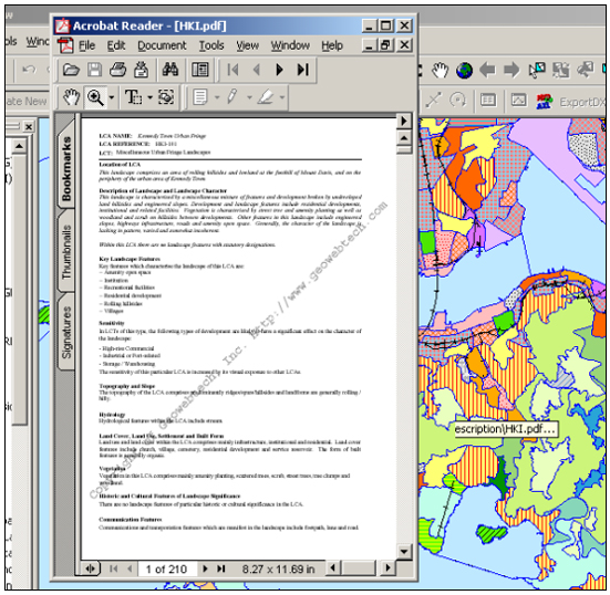
3.3.15 This folder contains a brief description of each LCA and its particular features. Polygon features in the 'Landscape Character Area' map layer are also hyperlinked to their corresponding 'Landscape Description' report file, which is in PDF format. Users can click on an LCA polygon and this will trigger the opening of that LCA's description file, which provides the user with detailed information about the local landscape.
USING THE GIS DATABASE
3.3.16 Technical information and instructions for the use of the GIS database are set out below. It is assumed that the user has available ArcInfo Version 8.3 and is familiar with its operation.
System Requirements
3.3.17 In order to make use of the GIS database, users need to have the following software packages installed on their workstation platforms (Windows NT/2000/XP):
ESRI ArcGIS 8.2 or higher (ArcView/ArcEditor/ArcInfo)
Apple QuickTime Player 5.0 or higher, which can be downloaded from http://www.apple.com/quicktime/
Any image viewer software which supports JPG format. Eg. IE
Adobe Acrobat Reader 5.0 or higher
3.3.18 It is also assumed that the user has at least 1.5GB empty space on their local D:\ Drive.
Installation Procedure
3.3.19 In order to make great use of the GIS database and to ensure optimum system performance, users are recommended to follow the steps listed below:
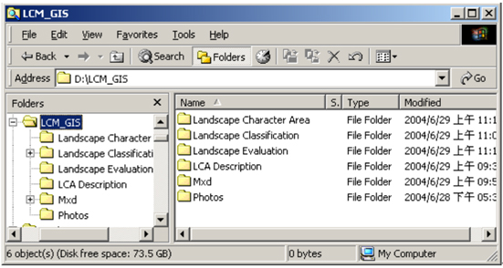
3.3.20 Copy the whole LCM_GIS folder to your local hard disk D:\ drive, keep the original directory structure.
3.3.21 Once copied, your LCM GIS database should look like:
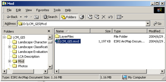
3.3.22 Open the LCM Map Document
3.3.23 Double click the LCM_GIS.mxd (ArcMap document)
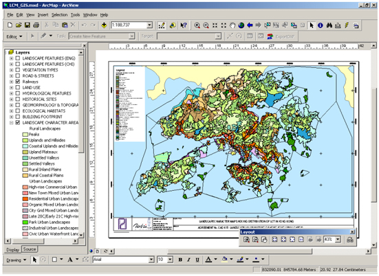
3.3.24 This will open ArcMap application and the landscape character map project will display the map in the layout window as below.
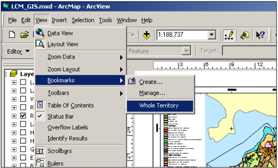
Using the Spatial Bookmark
3.3.25 In order to return to the preset map scale showing the whole territory LCA extents, a spatial bookmark is created for convenient usage. Just select View-->Bookmarks-->Whole Territory, then users will jump back to the original map scale as the above figure.
Multiple Hyperlinks
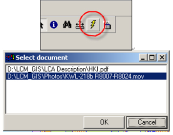
3.3.26 Each LCA polygon is linked to its corresponding field survey photo. In addition, users can also refer to a detailed description document of the LCA via the multiple hyperlink function. Field survey photos are stored in the D:\LCM_GIS\Photos directory, while LCA description documents in PDF format are stored in the D:\LCM_GIS\LCA Description folder.
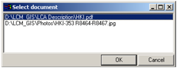
3.3.27 Users can click on a particular LCA polygon on the map, using the Hyperlink tool, which will then open the dialog box, asking the user which document he/she would like to open: field survey photo or LCA description report.
3.3.28 Documents with ".MOV" or ".JPG" extensions are field survey photos. If selected, the following screen will be displayed.
3.3.29 Documents with “.PDF” extension are field survey photos. When selected, the following screen will be displayed: